Mojave offers plenty of trails
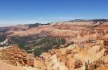
The return of cooler months to the desert invites exploration of the sprawling Mojave National Preserve just over the Nevada border in Southern California.
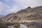
Although the preserve contains few established foot trails, hundreds of miles of old roads and historic trails lead hikers, mountain bikers, cyclists, four-wheelers and equestrians to probe washes, canyons and mountains. Always carry at least a gallon of water per person and extra for your vehicle. Let a responsible person know where you are headed and when you plan to return.
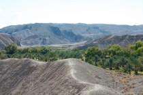
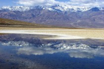
Administered by the National Park Service since 1994, the Mojave National Preserve sets aside a huge portion of the Mojave Desert, the smallest and driest North American desert. The preserve encompasses a rough triangle bordered by U.S. 95, Interstate 40 and Interstate 15, plus an area north of I-15 near Mountain Pass. Many areas of the preserve are less than a three-hour drive from Las Vegas.
These highways provide easy access to the network of 2,200 miles of roads and trails into the interior of the preserve. Visitors can use passenger vehicles safely on major routes through the preserve, but many graded roads and dirt tracks require high clearance vehicles or four-wheel drive.
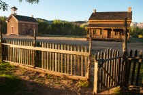
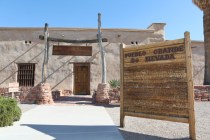
Before venturing off main roads, consult a good map. Learn about current road conditions at the preserve's information stations in California at Baker, Barstow, Needles, Nipton, Goffs Schoolhouse Museum on Route 66 or the visitor center in the restored Kelso Depot. Built in 1927, the two-story Mission Revival building served train crews and passengers on the Union Pacific.
Access the depot from near Nipton using the Morningstar Mine Road toward Cima and Kelso, the Cima Road from I-15 between Mountain Pass and Halloran Summit or from Baker on Kelbaker Road. The beautiful Kelso Dunes lie a few miles south of the depot. Visitors drive to them and park near the base of the 700-foot mountains of sand. Only foot traffic is allowed on these protected dunes. The soft, shifting sand precludes any defined trail, so it is a slog to the crest.
The Cima Road passes the trailhead to Teutonia Peak, a developed trail. Watch for an informal campsite at Sunrise Rock 10.4 miles south of I-15 on the Cima Road. The four-mile trail begins nearby on the opposite side of the road, cutting through an extensive forest of Joshua Trees, a signature plant of the Mojave.
Between Cima and Kelso, watch for the Cedar Canyon Road turnoff, an access to developed facilities, accessible from I-40 as well. Pavement soon turns to gravel through five flood-prone miles to the junction with Black Canyon Road. Turn south and look for a narrow two-mile road to Mid-Hills Campground, one of two developed campgrounds in the preserve.
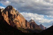
Continue south on Black Canyon Road to reach facilities at Hole-in-the-Wall, named for strangely eroded rock formations. Developments include a ranger station, housing for fire crews, an equestrian group campground, a 35-unit RV and tent campground, and two additional walk-in tent sites.
Both campgrounds have tables, fire rings, parking pads, drinking water and centrally located toilets. Fire restrictions may be in force. Plan to use a camp stove for cooking. Camping fees apply, but no entrance fee is charged. Reservations are not accepted, except for the equestrian facilities.
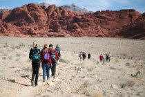
A popular eight-mile trail connects Mid Hills and Hole-in-the-Wall. Hikers, bikers and horseback trail riders often start from Mid-Hills, which sits 1,200 feet higher than Hole-in-the-Wall. They park transport vehicles at the visitor center/ranger station for the ride back, unless they want to do 16 miles roundtrip.
Margo Bartlett Pesek's column appears Sundays.