Riding the Rapids


For the umpteenth time in the past 15 minutes, I wonder, "What am I doing here?" Then I climb the final rope ladder to Travertine Falls in the Grand Canyon and I know why I came. I wanted adventure and I'm now getting a healthy dose of it.
Although Travertine Falls tumble down a gorge almost narrow enough to be considered a slot canyon, climbing that ladder isn't my only adventure on this one-day Grand Canyon whitewater raft trip offered by the Hualapai Nation. The fun began at 8 a.m. when photographer Bernadette Heath and I boarded the van at Hualapai Lodge in Peach Springs, Ariz., the capital of the Hualapai Nation. To get down to the Colorado River to catch our whitewater ride, we must go 22 miles down Diamond Creek Road, the only vehicle route that leads into the lower gorge of the Grand Canyon. A trail for thousands of years, then a trace of a road in the 19th century, it remains rough dirt, but a scenic adventure.
Diamond Creek Road actually descends Peach Springs Canyon. Our driver, Eliza Querta, and Earlene Havatone, recreation manager, explain the history of their people as we make the trip. There are fewer than 2,000 tribal members, and Hualapai land sprawls over 1 million acres along 108 miles of the Colorado River and Grand Canyon. Their land is not part of Grand Canyon National Park. The park service oversees the northern side of the Grand Canyon, while the Hualapais manage their southern edge. Tourism is the main source of income for the Hualapais, and they offer the only one-day whitewater rafting trip through the canyon.
That is what I am here to do. I want to ride the rapids, see the sights, marvel at the Grand Canyon from the air as I'm helicoptered out at Grand Canyon West and relish some Route 66 nostalgia on the way back to Peach Springs. And it's possible to do it all in a day.
Peach Springs Canyon quickly deepens, and we see signs of the natural springs that first drew people to this area. "This road is the only thing that cancels one of our raft trips. Even if it is snowing, we are on the river, but If we've had a bad storm, one of us drives this road about 3 a.m. to make sure that the vans can make it," Havatone says.
I notice pieces of heavy equipment parked off the road, handy to make quick road repairs.
We pass the entrance to Lost Man Canyon and are stopped by nine burros. Called hala'vado by the Hualapais, they are descendents of work animals abandoned by construction workers in the 1920s. These feral animals have survived well in this land of prickly pear, ocotillo and cholla cactus, but even a "wild" burro will seek a handout of store-bought people food.
The canyon narrows, and ahead is a large diamond-shaped peak, namesake of Diamond Creek. Then the road turns down Diamond Creek, and we drive through several inches of water as the road follows the stream bed toward the Colorado River.
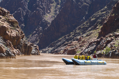
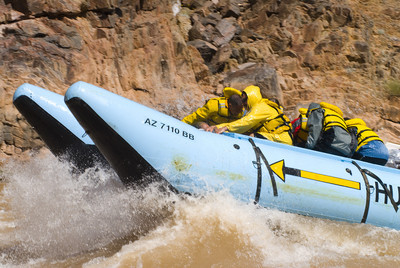
Waiting for us are two 23-foot, bright blue, motorized pontoon rafts. Tucked discreetly down a sandy trail are a couple of portable toilets. We're advised to visit these, because we won't be seeing any more for several hours.
Gary Gonzales, the supervisor, is our boatsman today and makes sure we are snuggly strapped into personal flotation devices. Seven of us join Gonzales on his raft: Mary Roy and her 17-year-old-son, Jamel, are from Massachusetts; Cheryl and Mike Huey from Jupiter, Fla., are on their honeymoon; and Havatone comes along to keep Bernadette and me in line.
The first question is "How soon do we get to the rapids?" Gonzales grins and points about 100 yards downstream. Apparently, we are going to get adventuring immediately.
We've all donned either rain suits, wet suits or ponchos, because these aren't ripples, but rapids and, believe me, there is a difference. The waves will splash clear over the raft, and the Colorado River water is 45 degrees year-round. It is best to dress in layers and remove the plastic wet gear when you're through the rapids. You'll need a strap on your hat and your glasses. Also, be sure any jewelry fits tight. My wedding band was loose, and the force of the waves washed it off my finger. If anyone asks whether there is gold in the Grand Canyon, I can say with a certainty, "There sure is."
In the Grand Canyon, distance is measured in "river miles," the number as the river runs from Glen Canyon Dam at Page, Ariz. We are putting in at Mile 224.6, Diamond Creek Beach in the Lower Granite Gorge. Rapids are described differently here than they are elsewhere. In most of the United States, rapids are rated from one to six, with six being something like going over Niagara Falls. The Grand Canyon uses "desert scale," numbering the difficulty of rapids from one to 10. A 10 rating means "I don't ever, ever want to do that."
Gonzales maneuvers the raft out into the current. With 14 years of experience, he eyes the coming rapid and picks out the smooth water, called the "tongue," as it enters the rapid and down we go, the start of our 40-mile river adventure. There is a collective scream, but I can't tell whether it is from the thrill of bouncing through the rapids or the shock of that 45-degree drenching we all get. According to Gonzales, Diamond Creek Rapid is rated a three, so it is just a frigid foretaste for what's ahead.
When I wipe enough water off my glasses to see, I'm awed by the magnitude of the Grand Canyon. Although, I've been in the canyon many times, I still feel insignificant here. Black granite walls are so smooth they shine. The river has polished this rock as well as any lapidary artist could. Side canyons provide glimpses of hidden scenery, and I wish I had the time and energy to explore every one.
I get my chance to check things out sooner than I think. We've been on the river for only four miles when Gonzales heads the raft to the shore and we clamor out to take a quarter-mile hike up to Travertine Falls. It is a moderate climb, so I resume wondering "What am I doing here" only when I have to climb up a steeply sloped rock by holding onto a knotted rope and leaning back.
The hike includes two sets of rope ladders (one right up the waterfall), boulders to scramble and water pockets to skirt. Thank heaven, the guides help. It is a climb, but it is worth it. Water gushes onto black schist -- rock formed from other rocks under intense heat and pressure -- that is topped with travertine. Travertine is mainly calcite and usually forms from hot springs. Over time, the calcite builds up into smooth rock that reminds me of vanilla taffy candy. I look up, and the sky is just a blue slit at the top of the canyon, and an immense boulder has rolled onto the top of the canyon. Standing there, looking up at the rock blocking part of the opening, my sense of personal importance shrinks from minor to insignificant.
Back in the raft and heading downriver again, I start noticing more rocks frosted with travertine. The canyon must be beautiful with waterfalls pouring off the cliffs. At a spot called Fluted Rock, the rock has been pushed to a vertical position and then polished smooth. I wish I'd paid more attention in my college geology class so I could understand better all the wonderful sights I'm viewing.
The next major rapid has the unromantic name of 231 Mile Rapid. Not much of a name, but it packs a wallop. It's rated a six, and we bob and weave up and over the waves, catching a quick breath between splashes of cold water. We pull to the edge and watch the second raft go through. That group screams as loudly as we do.
At River Mile 232, we come to the romantically named Honeymoon Rapids and verbally dedicate it to our own honeymoon couple, the Hueys. The rapid is named for Glen and Bessie Hyde, who tried to go through the Canyon in a sweep-boat on their honeymoon trip in 1928. The couple disappeared, and their boat was found near Mile 237 with Bessie's camera and diary aboard and nothing disturbed. River runners like to tell the story around the campfire at night and then add that many years later, an elderly woman was along on a raft trip. After the story had been told, she confessed to being Bessie Hyde. Who knows?
Honeymoon Rapid is rated eight and is like riding a wild rollercoaster. After that experience, we take the four- and five-rated rapids like pros. Gneiss Canyon is the narrowest point on our trip. The river is about 60 feet wide, and I feel the pressure of the canyon closing in on me. Here the gneiss -- another metamorphic rock formed from heat and pressure -- is polished to a satin, funeral black, filling us with foreboding. Rocks that were laid down flat are now pushed into upright positions. Nature's impressive power is on display here.
Gonzales points out a rusted door high on the canyon wall. Behind that door, explosives were once stored for the effort to build Hualapai Dam, which, according to Gonzales, might have flooded the Grand Canyon even before Hoover Dam was built downstream. Not only is the river narrow here, but the cliffs are higher and the top layer is sheer-faced. We see remnants of rock walls where construction crews had their camps. A cable that supported the waterline pipe still stretches across a side canyon. All supplies for the men doing the early site work were brought in by burros, the ancestors of those that met us on Diamond Creek Road. Plans for the dam were not officially scrubbed until 1984.
At lunch time, we stop at Separation Canyon. I feel slightly guilty gorging on sandwiches, cookies, chips and cold drinks because I know the story behind the name of Separation Canyon. When Maj. John Wesley Powell led the first river exploration of the Colorado River in 1869, his group met with one catastrophe after another. By Aug. 28, they were almost out of food and their boats were badly damaged. They stopped at this side canyon and all they could see coming up on the Colorado River was another rapid and more steep canyon walls. The Colorado River must have seemed like a never-ending hell. Three members of the party decided they would try to climb out this side canyon. Powell and five others were determined to see the voyage through. The remaining flour was cooked into biscuits and divided equally and the three left at sunup. They were never seen again, and many think they were killed by Indians.
What neither group realized was that Separation Rapid is the last of the large rapids. Powell and most of the crew emerged the next day at the Mormon settlements near the mouth of the Virgin River.
After stuffing our stomachs, we start stuffing our pockets with agates, fossils, limestone and any number of unidentified rocks that have washed down Separation Canyon. We've gone rock crazy and plan to take home rock souvenirs until we're reminded we will soon ride out on a helicopter and that the wind has picked up.
Everyone groans and empties his pockets where he stands.
Some stack their treasures into small cairns. But there will be no dangerous extra weight on the helicopter today.
We're back on the river, and ahead are three peaks. Havatone tells us they are named Coyote, Bear and Mountain Lion, and are part of the Hualapai origin story.
At last comes the stop everyone has been waiting for, Spencer Canyon.
It is unusual because of a large lava formation, but most people are more interested in the porta-potties.
The river now slows and widens, we've shed our wet gear and are on a relaxing float.
I have time now to notice caves in the higher cliffs, and little canyons that appear with magical suddenness; quite appropriately, one is named Surprise Canyon. Mallard ducks enjoy the water, too, and are unconcerned when we float past.
Too soon we reach Quartermaster Canyon, the end of our 40-mile river adventure. It is now time for some high flying, then a two-hour van ride back to Peach Springs. The helicopter is waiting, and we each have to weigh. The pilot says it is so they can balance the loads, but I think they heard about the rocks at Separation Canyon.
As the helicopter rises out of the bottom of the Grand Canyon to land us safely on the rim at Grand Canyon West, I wonder what Lt. Joseph Christmas Ives would think if we could take this river trip. In 1857, the government authorized him to explore the Colorado from the south to see how far steamboats could come up the river. He wrote:
"The region is, of course, altogether valueless. It can be approached only from the south, and after entering it there is nothing to do but leave. Ours has been the first, and will doubtless be the last, party of whites to visit this profitless locality. It seems intended by nature that the Colorado river, along the greater portion of its lonely and majestic way, shall be forever unvisited and undisturbed."
Ives, of course, had to do his explorations without the conveniences of helicopters and porta-potties.
If he remained unimpressed by his voyage, mine has been just great.
GETTING THERE
Location: Grand Canyon West on the Hualapai Reservation. Headquarters is Peach Spring, Ariz., 155 east of Las Vegas.
Directions: Take U.S. 93 southeast from Las Vegas 104 miles to Kingman, Ariz. Take Exit 48 onto Interstate 40 toward Flagstaff/Phoenix for 4 miles. Take Exit 53/U.S 66/Andy Devine Avenue heading north and follow Historic Route 66 for 47 miles to Peach Springs.
Best time to visit: April-October.
General information: One-day whitewater rafting trip costs $328 plus tax; book at destinationgrandcanyon.com (888) 255-9550, or (928) 769-2219. If booking less than seven days ahead, do it by phone and not online. Fee includes 22-mile trip from Peach Springs down Diamond Creek Road to Grand Canyon, 40-mile raft trip, snack, beverages and lunch (vegetarian available), dry storage container, helicopter ride out of canyon and two-hour van trip back to Peach Springs. Trips offered from March 15 to Oct. 31. Tours last 10 hours including pickup and return to Peach Springs. Children must be at least 8 years old.
Trip starts at 8 a.m. at the Hualapai Lodge, 900 Route 66, Peach Springs, (888) 255-9550, (928) 769-2230, www. destinationgrandcanyon.com/lodge.html. The Diamond Creek Restaurant inside the Hualapai Lodge serves breakfast, lunch and dinner.
How to dress: Temperatures at river level in the Grand Canyon are about 20 degrees warmer than at Peach Springs, but Colorado River water is 45 degrees. Dress in layers, bring rain suit or poncho to wear through rapids, use sunscreen. Hat and glasses need straps. Expect to be very hot and very cold on the same trip.