Grand Canyon’s North Rim’s permanence and solitude make for a tranquility — PHOTOS


The last time I’d seen the Grand Canyon’s North Rim was as a 10-year-old on an overnight layover halfway through a weeklong, rim-to-rim-to-rim hike with my family.
Decades later, looking out over the canyon below, nothing had changed.
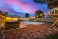
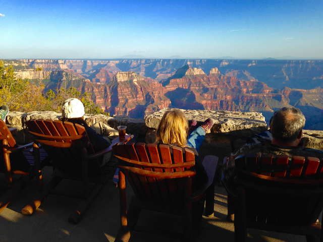
The Grand Canyon Lodge perched on the rim’s edge stands as it has since 1937, a limestone edifice that remains the vast North Rim’s only nod to hot showers and evening cocktails. The canyon’s rainbow striations, uncharted mesas and yawning vistas testify to the imperceptibly slow march of geologic time, in which a few hundred feet of movement are measured over eons.
THE NORTH RIM’S QUIET PERMANENCE COMES PARTLY FROM ITS LOW VISITOR VOLUME.
Open only from May 15 to October 15, the rim ranks as one of the least-visited corners of the national parks system. Its 500,000 visitors a year equals a tenth of the 5 million people who visit the South Rim annually, and a quarter of the 2 million who pass through the gates each year at Red Rock Canyon National Conservation Area. It’s also less than half of the 1.1 million yearly visitors who brave Death Valley.
The bigger factor, though, is how long it takes for water to carve countryside. Segments of the canyon’s walls are 1.8 billion years old; the Colorado River began sculpting the natural wonder 6 million years ago. The numbers are debated, but a 2012 study from researchers at the University of Colorado and the California Institute of Technology showed the canyon deepening 330 to 660 feet every million years.
Those two factors — solitude and slow time — make for a mellow, contemplative journey just three hours from Las Vegas’ commotion. Throw in summertime highs in the low 80s, and the North Rim offers a blessedly cool escape as well.
To match its low visitor counts, the North Rim doesn’t have nearly the number of hiking trails, campgrounds or villages as the South Rim. That leaves time to explore other sites in the neighborhood.
A STARTING POINT
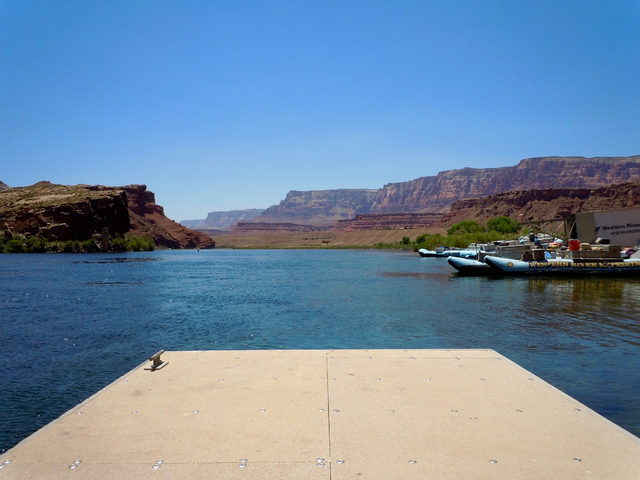
We decided it would be fitting to launch our journey where the Grand Canyon itself begins — at Lees Ferry, 85 miles northeast of the North Rim on U.S. Highway 89A. Lees Ferry marks the place where white settlers first successfully crossed the Colorado — an 1864 journey that included 15 men plus horses and supplies. Famed explorer and geologist John Wesley Powell and Mormon leader Brigham Young navigated the passage together in 1870.
Today, the historic site marks the only place on the Colorado River’s 700 miles where you can drive to the water’s edge. There, we stood alongside the Grand Canyon’s first rapid and watched expedition crews prep rafts for tours downstream. Kayakers paddled up to the dock from Glen Canyon National Recreation Area to the north. Less than 1,000 feet up the shore stood ruins — stone buildings, steam boiler, paddlewheel boat — from a failed 1910 attempt to mine gold.
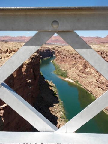
Nine miles north on Highway 89A, we found another historic breakthrough — man’s first successful effort to conquer the Colorado through modern engineering. The first bridge over the river, Navajo Bridge, opened in 1929 after two years of construction. At nearly 500 feet above the river, the structure was the world’s highest steel-arch bridge when it debuted.
A new Navajo Bridge opened alongside the original in 1995 to accommodate heavier vehicles and more traffic. But the first Navajo Bridge still spans the river, serving today as a pedestrian walkway. We paced the entire bridge, pausing to gaze down at the emerald Colorado burbling below at a lazy 4 miles per hour.
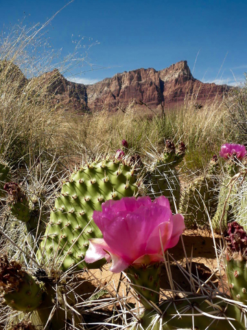
On our way toward the North Rim from Navajo Bridge and Lees Ferry, we enjoyed a front-seat view to one of the world’s best-known hiking destinations. Vermilion Cliffs National Monument, an imposing, red wall of rock, spans more than 20 miles along Highway 89A. It’s not a place for a casual hike: It’s true wilderness, with no roads, and permits are required to hike on many of its trails. But Highway 89A offers several scenic — and photo-friendly — overlooks of the cliffs.
We ended our day at Jacob Lake Inn, about 30 miles north of the national park’s north entrance. The compound, with motel rooms and cabins, proved its worth as its own mini-destination.
At the Kaibab Plateau Visitor Center next door, we took in interpretive displays of the region’s forests, formation, and flora and fauna. We learned how Native Americans forged a life on the land. We saw, through artifacts from the U.S. Forest Service’s early days, how the region morphed into a tourist attraction.
Jacob Lake Inn also houses a small general store, a bakery that whips up blueberry turnovers and peanut butter chocolate chip cookies, and an ice cream counter that sells “above the rim” milkshakes, which tower two inches above the top of the cup and require a spoon for eating. There’s also an extensive gift shop, and a dining room with forest views and local arts and crafts for sale on the wood-paneled walls.
After dinner, we attended a weekly photography seminar led by Matt Rich, whose family founded Jacob Lake Inn in 1923, and whose desert studies grace gallery walls across the Southwest. The session covered the basics of lighting and composition, and included pro tips on computer programs that improve pictures.
Rich’s class came at the perfect time: We planned a 4 a.m. alarm to capture one of the world’s most glorious sunrises — dawn at the Grand Canyon’s highest point.
SCENERY AND SOLITUDE
At an elevation of 8,803 feet, the North Rim’s Point Imperial towers over the rest of the Grand Canyon. It stands a fifth of a mile above the South Rim’s apex, Grandview Point. That height, say locals, makes the point the best place in the canyon to snap sunrise.
The drive from Jacob Lake to Point Imperial took us on a gently winding highway through a landscape notably different from the South Rim’s desert juniper forest. We slipped in shimmering moonlight past Ponderosa pine forests mixed with subalpine meadows, and fire-scarred hillsides pushing up fresh groves of young aspen trees. It’s not a drive that lets you drift mentally: We saw dozens of mule deer grazing alongside the road and had to stop every few miles to let them cross.
The tortuous trek was well worth it. Point Imperial grants soaring views of the Grand Canyon’s eastern end, including the Painted Desert and Marble Canyon. As the sun cleared the horizon on our morning there, colors in the canyon below shifted from muted purples and grays to vivid pink, red and tan bands of rock. Daybreak also gave us just enough cloud cover for some striking shadows.
Here and along the rest of the North Rim, geology is the photographer’s friend. The higher elevation gives the region twice as much rain and snow as the South Rim. Snowmelt-filled washes and creeks etched dozens of side canyons and rock islands over millions of years. The result: dramatic rock formations, steep falloffs and 100-mile views.
For a stronger sense of the geologic drama, we drove the rest of the rim’s must-see scenic drive, a 23-mile stretch of winding road that ends at the Cape Royal outlook. The drive took just half the morning, including time for stops at several highlights.
At Vista Encantada, a lone picnic table perched on the rim overlooked the Walhalla Plateau, with its seasonal water flows and rich vegetation.
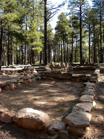
The Walhalla Ruins turnoff harbors the 900-year-old stone foundations of an Anasazi settlement, a summer home the tribe used to grow beans, corn and squash. The shady haven gave us our lone glimpse of the rare Kaibab squirrel, found nowhere else in the world beyond the North Rim. The foot-tall squirrel darted into the woods, his fluffy, white tail disappearing before we could grab our cameras.
Halfway along the scenic drive, we got our first look at Angel’s Window, a nearly perfect square hewn from a wall of rock by fractures and weather. Sixty miles in the distance, snowcapped Humphreys Peak — Arizona’s highest point, at 12,637 feet — provided an impressive backdrop.
Even better views awaited at the scenic drive’s end.
If Point Imperial offers the North Rim’s highest vantage point, Cape Royal promises the most panoramic vistas. At the southernmost tip of the North Rim, Cape Royal’s 270-degree view wraps from Marble Canyon to the north all the way down to the South Rim’s visitor center more than 10 miles across the gorge. On a clear day, visitors can see as far as 100 miles.
And they can enjoy that view mostly alone: On the entire three-hour drive, including the half-dozen side trips we made, we met just five other people. We saw only one other visitor at Point Imperial, snapping photos a few hundred feet down the hillside. At Vista Encantada, we heard only a hawk screaming. At Cape Royal, we stood alone with the wind in the trees.
The scenic drive and its quick side trips gave us unforgettable views of the canyon below, but we wanted at least one serious hike.
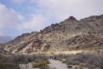
The North Kaibab Trail is the rim’s most popular option. But unlike the scenic loop and its quiet paths, the Kaibab trail was positively mobbed the day we visited. It’s also a relatively strenuous hike, with elevation changes of 3,000 feet in less than five miles.
So we settled on Widforss Trail, a less-traveled footpath that keeps a relatively level track along the rim. The 10-mile hike alternates between meadow and forest, with stands of Aspens, groves of oak and maple, and clusters of 500-year-old Ponderosa pines. Along the trail, we saw as many mule deer — two — as we saw people.
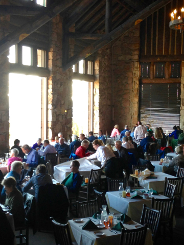
A day of sightseeing left us hungry, and that could mean just one thing: A visit to the Grand Canyon North Rim Lodge. It’s the only place in the park’s north side with food service. You won’t find peace and quiet there, but the sprawling complex has everything else — visitors center, gift store, dining hall, deli and ice cream parlor and auditorium with buffet meals.
There’s also a patio with sweeping canyon views, and a lookout room where we ordered hot chocolate and watched a ranger’s presentation on the reintroduced California condor, once nearly extinct but now thriving in the Grand Canyon. Roughly 70 of the birds frequent the area, easily visible to hikers below thanks to their nine-foot wingspans. In addition to the Grand Canyon, Vermilion Cliffs is home to condors, though we didn’t see any on our trip.
We made our North Rim sojourn in about 36 hours.
If you have another half-day, several other nearby attractions beckon.
Pipe Spring National Monument, on Arizona Highway 389 about 14 miles southwest of Fredonia, features remnants of settlements by Puebloans more than 1,000 years ago, Catholic missionaries who passed through in the 1700s, Mormon pioneers of the 1860s, and today’s Kaibab Paiutes, who maintain a cultural museum on the site.
Grand Canyon-Parashant National Monument, a 1 million-acre wilderness due west of the Grand Canyon and east of Lake Mead National Recreation Area, has a varied landscape that includes desert washes, a Joshua tree forest and a pinyon-juniper woodland.
And another world-famous national park — Zion — 125 miles away, up Utah Highway 9 in Springdale.
At Zion in the summer, you won’t find the seclusion and the silence you’ll enjoy at the North Rim. But you will see the same ageless countryside, standing virtually unchanged in our lifetimes.
If You Go
GETTING THERE
The North Rim is 255 miles, or about four hours, from Las Vegas. Take Interstate 15 up through St. George, Utah, and exit east at Utah Highway 9 in Washington. Pick up Utah Highway 59, which turns into Arizona Highway 389, to U.S. Highway 89A. Head south at Arizona Highway 67, which takes you right to the north entrance of Grand Canyon National Park.
LODGING
Grand Canyon Lodge North Rim: The only lodging inside the Grand Canyon on the North Rim, this resort has motel rooms, plus cabins that date to the 1920s. Arizona Highway 67, North Rim, Ariz. 877-386-4384.
Jacob Lake Inn: Family-owned since 1923, the compound about 30 miles of the park's north gate offers a hotel, motel, and one- or two-room cabins with private decks. Arizona Highway 67 at Highway 89A, Jacob Lake, Ariz. 928-643-7232.
Kaibab Lodge: Dating to the 1920s, this lodge is about five miles from the park's entrance. The lodge prides itself on helping guests disconnect — it boasts no in-room TVs or phones, and no cell service. Grand Canyon Highway, Fredonia, Ariz. 928-638-2389.
CAMPING
The North Rim has just one campground of roughly 80 sites, so reservations are suggested. Cost is $18 to $25 per night, with a maximum of two vehicles, six people and three tents per site. The campground does have a handful of sites for larger groups. 877-444-6777.
DINING
Main Lodge Dining Room, Grand Canyon Lodge North Rim: Serving breakfast, lunch and dinner alongside floor-to-ceiling windows with panoramic canyon views, the dining room's menu focuses on regional and 1930s-themed dishes. Specialties include elk chili, Navajo tacos with traditional Native American fry bread, venison meatloaf and bison flank steak. 928-638-2611.
Deli in the Pines: This is the North Rim lodge's more casual dining venue, with pizzas, sandwiches, salads and ice cream. 928-638-2611.
Dining Room at Jacob Lake Inn: Breakfast, lunch and dinner. Popular offerings include baked, almondine filet of regionally grown trout; "campfire" chicken marinated for 24 hours and slow-cooked with onions, carrots and red potatoes; and pork chops slow-cooked in a Dutch oven. 928-643-7232.
Kaibab Lodge Restaurant: Basic fare breakfast and dinner fare includes pancakes, omelets, burgers, pastas, steak and chicken. Homemade pies and cobblers are on the dessert menu. 928-638-2389.