Flood-battered Mount Charleston neighborhoods recovering


The Rainbow Canyon neighborhoods on Mount Charleston, battered by floodwater and debris, are still scrambling to recover from damage caused by a summer storm on Monday.
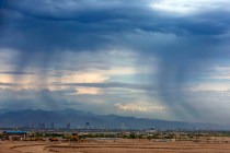
A flash flood warning Monday morning was followed by a deluge of rain totalling more than 2 inches. The rain quickly turned into intense flooding, sending large rocks and debris
The rain triggered a flood that sent large rocks and debris through neighborhood streets and washed away parts of the main subdivision roads.
“Public works crews have been working feverishly to get residents back in,” said Clark County spokeswoman Stacey Welling said Tuesday.
Rainbow Canyon Boulevard had been a paved road until flooding last year washed it out, she said. The county put down gravel, and crews were preparing to repave the road.
“We were planning to pave it in the next few days, basically, but then the storm came,” Welling said.
The project had an estimated cost of $150,000 before the storm, but the recent damage added another $75,000 or so, she said.
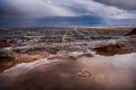
Roads were washed out by mid-afternoon, leaving rocky mounds and fissures nearly 7 feet deep in parts.
Monday’s flooding on Mount Charleston also damaged homes and caused a severe leak in the Kyle Canyon Water System, compromising water quality within the Lower Rainbow Subdivision of Kyle Canyon.
Welling said 10 homes were damaged by the flood, and at least five had varying amounts of debris in them.
The Las Vegas Valley Water District advised residents between Moritz Way and Rainbow Canyon Boulevard to boil water before using it for drinking, food preparation, brushing teeth, washing dishes and making ice on Monday.
The water advisory remained in effect on Tuesday, with service restored to most residents, the water district said. Repairs were expected to be completed within 48 hours, and bottled water was made available to residents along Ski Trail Road.
The U.S. Forest Service is keeping several trails closed in the Spring Mountains National Recreation Area. The South Loop, Griffith Peak, Cathedral Rock, Echo Trail and Little Falls trails are closed due to hazards associated with last year’s Carpenter 1 wildfire, which burned 27,800 acres in the Spring Mountains. Hazardous trees, debris flows and unstable trail conditions all pose risks. The other flooded recreation areas are closed until repairs are completed, the forest service said.
Although Cathedral Rock, Echo and Little Falls trails were not directly impacted by the fire, they all cross drainage channels that carry debris from the ridgeline above, which could be dangerous to hikers during heavy rains.
The lower portion of the Cathedral Rock Picnic Area, Foxtail Group Picnic Area, Deer Creek Picnic Area, Saw Mill Picnic Area and Hilltop Campground are still open.
The U.S. Forest Service said will have to consult with the U.S. Fish and Wildlife Service to determine what impacts to the endangered Mount Charleston Blue Butterfly’s habitat along the ridgelines could be caused by trail maintenance before it can begin.
Contact Wesley Juhl at wjuhl@reviewjournal.com and 702-383-0381. Find him on Twitter: @WesJuhl.