
Ecomapper might offer new perspective on lake
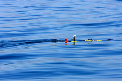


It looks like a torpedo but acts like a robot when it glides through Lake Mead looking for submerged objects, collecting water quality data and mapping the lake's bottom.
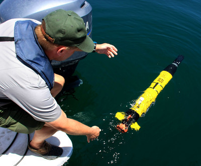
The Ecomapper, as it's called, is a $100,000 tool that was demonstrated Friday for the National Park Service and water agencies charged with ensuring that the lake's aquatic resources -- both natural and cultural -- are intact and Southern Nevada's primary water supply is safe to drink.
"Water quality data is always important to us. This thing gets it much more efficiently," said Dave Conlin, an archaeologist with the park service's Submerged Resources Center in Santa Fe, N.M.
With an array of sensing and sonar devices and an on-board computer system that can send data wireless to a touchscreen computer on a boat or the shoreline, the Ecomapper has made the agencies' wish lists.
Among the first things Conlin would use it for is to survey Fort Callville, a submerged ferry landing where supplies were delivered up the Colorado River more than a century ago for miners and ranchers.
It could also be used to explore Rioville, a town from the late-1800s that's been at the bottom of the lake's Overton Arm since the lake filled up behind Boulder Dam in 1935.
The 40-pound, 5-foot Ecomapper, unlike other submersible equipment, is programmed to run untethered on a programmed course using GPS. Propeller-driven, it runs on lithium-ion battery power for 10 hours traveling at 31/2 mph during the day, night and in inclement weather.
It has the capability to search for sunken boats, airplanes and drowning victims.
If it runs into something, it's programmed to get itself out of distress, said Daryl Slocum, director of Business, Development and Strategic Projects for YSI Inc., the Yellow Springs, Ohio, company that manufactures the Ecomapper.
The device can measure at least six types of factors that affect water quality, including temperature and turbidity.
Conlin said biologists are also interested in its potential for mapping areas of the lake that are more infested with colonies of invasive quagga mussels than others. Quagga mussels, first found in the lake in January 2007, are rapidly spreading and are beginning to clog marine equipment and water conveyance systems, and affect dam operations.
"We can program it to run all the way across Boulder Basin at 10 feet off the bottom, turn around and come back at 20 feet off the bottom and get our data in three dimensions instead of two," he said.
Conlin said park officials are really interested in acquiring an Ecomapper, especially if the cost can be shared with the Bureau of Reclamation and the U.S. Geological Survey.
"We have to come up with new ways to responsibly spend public money," he said.
J.C. Davis, a spokesman for the Southern Nevada Water Authority, said it's too early to say what the authority's level of interest is.
"It's the first chance we've had to get this thing out in the field and kick the tires as it were. It certainly has some very, very intriguing prospects to it," he said.
Contact reporter Keith Rogers at krogers@reviewjournal.com or 702-383-0308.


