
LV will be walking in a winter wonderland today


Measurable snowfall is expected to greet Las Vegas Valley residents today for the first time in more than five years, according to the National Weather Service.
"We are definitely looking at snow across the valley in the early morning," weather service meteorologist Larry Jensen said Sunday.
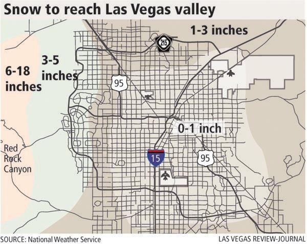
Jensen said between 1 and 4 inches of snow is expected to fall in valley areas below 4,000 feet.
A winter storm warning for heavy snow remains in effect from 4 a.m. to 10 p.m. today for southern Clark County and surrounding areas.
The weather service cautioned morning travelers and commuters to be vigilant about hazardous driving conditions such as slick roads and reduced visibility.
Snowfall for Mount Charleston and areas above 4,000 feet is expected to range between 6 and 12 inches.
Jensen said the possibility of snow or rain today is 90 percent because of an incoming storm system generated over the Pacific Ocean.
Jensen said the western valley has the greatest chance of snow accumulation.
The last time measurable snow sprinkled the Las Vegas Valley was Dec. 30, 2003, when 1.3 inches of snow fell, Jensen said.
Today's high temperature is expected to be 44 degrees, with a low of 31 degrees. Tuesday's high and low temperatures will be 48 degrees and 31 degrees.
There is a 40 percent chance of snow or rain on Tuesday. The chances of snow or rain on Wednesday is about 50 percent, Jensen said.
Northern Nevada was blanketed in white on Sunday, when a snowstorm lifted the spirits of skiers and frustrated motorists in the Lake Tahoe area.
Chains were required on all three highways linking the Sacramento, Calif. and Tahoe areas: Interstate 80 over Donner Summit, U.S. 50 over Echo Summit and Highway 88 over Carson Pass.
The Squaw Valley and Alpine Meadows ski resorts just north of Tahoe reported more than a foot of snow from the weekend storm.
Boreal atop Donner Summit reported 10 inches of new snow, saying it allowed the opening of more terrain. The ski area has three lifts and four trails in operation.
The National Weather Service called for a chance of another 1 to 2 feet of snow in the northern Sierra through Tuesday afternoon.
Along the eastern Sierra, the weather service called for another 6 to 12 inches of snow over the same period.
A winter storm warning remains in effect for the Reno-Tahoe area through 10 p.m. today. Before the weekend storm, the Sierra snowpack was only 2 percent of average for the date.
The Tahoe basin's snowpack ended at about 85 percent of average last season, a second below-average year in a row.
The Associated Press contributed to this report. Contact Antonio Planas at aplanas @reviewjournal.com or 702-383-4638.


