

Las Vegas officially reached its first 110-degree day Thursday, the earliest point in the year in the valley’s recorded weather history.
Las Vegas officially reached its first 110-degree day Thursday, the earliest point in the year in the valley’s recorded weather history.

Kevin Schenk was playing Face Up Pai Gow when he was dealt five aces, winning a $219,578 jackpot with a $5 side bet.

Morning lows will be in the mid-70s, with highs at or near 100 into next week.

A weak trough passing north of Las Vegas will bring some gusty winds as the only blemish on a Memorial Day weekend forecast, says the National Weather Service.

Highs near 95 are forecast Tuesday through Thursday before a possible 100 degrees on Friday, according to the National Weather Service.

Highs in the 90s forecast starting Mother’s Day and rising higher next week.

Central Las Vegas winds around 30 mph should drop to the single digits after sunset, says the National Weather Service.

What does it take to be considered rich in Nevada? Analysis from GoBankingRates determined the average household income of the top 5 percent of earners in each state.

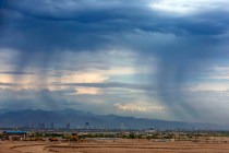
The heaviest storm activity during the afternoon was in the mountains on the southern edge of Henderson.

The Thursday high should be near 81, with afternoon winds of 9-15 mph gusting to 22 mph.
Winds, cooler temps and possibly some rain on Friday is in the Las Vegas forecast for the week, says the National Weather Service.

April 18 is the average date for the Harry Reid International Airport reaching 90 degrees, the National Weather Service said.

A wind advisory for the entire region runs from 2 to 11 p.m. Saturday when winds in the central Las Vegas Valley are expected to reach up to 50 mph.

Spring in Las Vegas this year has been very similar to last year, with the first 80-degree day nearly a month behind normal.

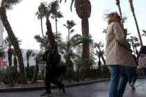
All-day wind gusts rattle the Las Vegas Valley. Friday morning wind chills may be in the 30s in parts of the valley.
The first 80-degree day may arrive Wednesday shortly before a possibly raw Friday, says the National Weather Service.
Moisture remains possible on Sunday forecast with a morning low dropping to around 42.

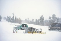
The storm is expected to be at its worst from Saturday afternoon into late Saturday night. Heavy snow above 6,000 feet is expected.

Clouds will increase Friday and winds will escalate from 9-14 mph in the morning to gusts up to 20 in the afternoon. Skies will be partly cloudy Friday night.

The Wednesday outlook is for a high of 77 with perhaps a degree or two higher on Thursday when winds could gust to 20 mph. The official outlook for Friday is 79.

Lee Canyon and Brian Head are extending their winter sports seasons as the Spring Mountains get ready for more snow to fall this weekend.


