
On the Road


Utah's Scenic Byway 12 is not yet as famous as it's going to be. Some of it wasn't even paved until a couple of decades ago, and the wonders to be experienced there have been well publicized only six years, since the secretary of transportation named it an All-American Road. That's the most prestigious designation the agency can award, given so far to only a few dozen routes in the country.
The byway rambles 124 miles through the most spectacular country of a colorful state, starting south of Panguitch, near Bryce Canyon National Park, and ending in Torrey, near Capital Reef National Park. In between you will find mountains, plateaus, canyons, riparian corridors and ranch communities; you will travel through national forests, national parks, state parks, a national monument, a couple of towns devoted to ranching and a couple devoted mostly to adventure sports.
Earlier this month my 11-year-old daughter, Charlotte, and I revisited some of our favorite places and found a few new ones on or near this remarkable road. We started our four-day adventure just two miles into the byway at Red Canyon, part of Utah's Dixie National Forest, where pink Claron limestone formations rival those of nearby Bryce Canyon.
Since we had brought bikes along, we couldn't wait to pedal the city air out of our lungs. We skipped the two most popular bike trails: a 5.5-mile paved cruiser as well as the demanding 8-mile Thunder Mountain Trail. Our choice was a gravel Forest Service road in the Cabin Hollow area. Riding side by side, we spent about an hour on relatively flat terrain within the rock formations, admiring meadows dotted with blue, purple and yellow flowers, announcing the start of wildflower season.
It was sunny yet very cold when we visited. But the weather will be perfect come summer, thanks to the byway's high elevation, ranging from about 4,000 feet to more than 9,000.
Back in the car, we followed the byway up about five more miles to the Paunsaugunt Plateau to see an old airplane hangar at the Bryce Canyon Airport. This 80-by-80-foot barnlike structure was constructed in 1936 as a joint project of Garfield County, the Works Project Administration and the Civilian Conservation Corps. As was the habit of such depression-era programs, they used local materials -- ponderosa logs. This unique pioneer-style accommodation for air-age technology is now on the National Register of Historic Places.
Since both of us have spent many days, on previous trips, in famous parts of Bryce Canyon, we bypassed the park's main entrance and visited little-known Water Canyon, on the park's east side. Here we took the Mossy Cave Trail, which follows the perennially flowing creek through the park's signature red and orange limestone hoodoo formations.
After less than one-half mile, the trail forks. To the left, 50 yards or so farther, we found Mossy Cave. This spring-fed cave boasts icicles much of the year and a miniature forest of mosses year-round.
Returning to the fork we headed up to the top of a waterfall. Water is abundant here now thanks to the engineering and effort of the Mormon pioneers who dug "the Tropic Ditch."
When the pioneers arrived in the 19th century, they found little water in the valley to sustain crops, pastures and animals. These intrepid souls spent two years digging a 10-mile ditch diverting water from the East Fork of the Sevier River on the plateau above to the canyon rim. From there, the water flows down natural drainages through the Mossy Cave area and then down through another man-made drainage into the Tropic area, just east of here.
Continuing along the byway, we stopped at a few ranching communities including Tropic. Here we visited the Ebenezer Bryce house, a hand-hewn-log cabin about as big as an undersized modern bedroom. Bryce, a pioneer cattleman, homesteaded this area, and is remembered for his description of the chasm that now bears his name: "Well, it's a hell of a place to lose a cow." If you have ever spent time staring down the steep terrain into the canyon's tightly packed hoodoos, you will get a chuckle at the colorful accuracy of his remark.
The small ranching community of Escalante was our next stop and where we would stay for the next two nights so we could explore the immediate area. The town was settled in 1875 and named after Father Silvestre Velez de Escalante, a Spanish missionary who came to this area on an expedition in 1776.
We checked into the Circle D Motel, where we had stayed before, and were surprised to find it had been remodeled. Refrigerators and microwaves have been added to the rooms, wireless Internet service is now reliable and one of the two buildings has been redone inside and out, top to bottom, with new furnishings. A restaurant on the property will open later this year.
Unwilling to wait that long for dinner, we walked down to Escalante Outfitters, where adventurers go to fill up on pizza and maybe beer, check their e-mail or use the pay phone to contact loved ones. (In the canyons and along the majority of the Byway, cell phones don't work.) Many of the customers have just come off of, or are about to embark on, extended hiking or backpacking trips into the canyons of the Escalante, one of the premiere places for canyon hiking in the world. It's the busiest business in town, also offering guided fishing tours, mountain bike rentals, cabins and camping facilities as well as sell high-end outdoor equipment.
The next morning we headed south of town to Hole-in-the-Rock Road, a 62-mile gravel route in Grand Staircase-Escalante National Monument. In 1880, Mormon settlers seeking a shortcut to the San Juan area made their way down through here on what turned out to be a six-month expedition. In many places flanking the road, you can still see the old rutted wheel tracks of their trail. Once reaching the Colorado River, they found that the only way to access it was lowering their wagons hundreds of feet down a steep cliff to the canyon below. This canyon is now part of Lake Powell in the Glen Canyon National Recreation Area. You can drive all the way to the drop-off into Lake Powell, but the last few miles are so rough it's practically faster to walk or ride a bike. The entire road is impassable in rainy weather.
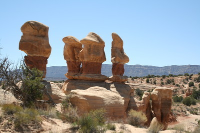
I had visited several places in this area on trips without Charlotte, and was eager to show the best to her, so we headed to a trio of slot canyons in the Dry Fork of Coyote Gulch: Peek-a-Boo, Spooky and Brimstone. Charlotte, full of the energy and confidence appropriate to her youth, reveled in the climbing, crawling and fitting into impossibly tight places. On our way back to town we made a brief stop at Devil's Garden, where we had a picnic and explored the formations and arches.
Before calling it a day, we stopped at Escalante Petrified Forest State Park, about one mile from town. We had hoped to rent a canoe to explore Wide Hollow Reservoir, but the office worker in charge felt the water was still so cold that our survival might be in doubt if we happened to require rescuing. I thought this was excessively cautious, but we remained landlubbers. Exploring the park's trails allowed us to see some petrified wood that dates back 160 million years.
The next morning we were up at sunrise, checked out of our motel and were back on the road. About 15 miles out of Escalante the terrain changes dramatically as the road serpentines down through miles of slickrock terrain. This section is known as Head of the Rocks and was built by the Civilian Conservation Corps, who completed it in 1935. This ambitious endeavor opened up a new section of Utah for travelers. It wasn't until 1971 that this section was paved.
Heading down we stopped at Boynton's Point and caught our first glimpse of the Escalante River where the byway crosses it. The Escalante was the last river to be discovered and mapped in the contiguous United States. Captain James Andrus in 1866 led fellow cavalrymen into the river near the present town of Escalante. Jacob Hamblin, who was enlisted by the second Powell expedition in 1871, was the first Anglo to pass through the Escalante River Canyon.
Although this area now looks much like it did when whites first saw this area, it hasn't always. The fragile ecosystem was once overgrazed to the point of ruin, but in 1949 the Bureau of Land Management stepped in with a grazing management plan. It took nearly 60 years, but most of the damage has been reversed.
This is a beautiful riparian corridor thick with Fremont cottonwoods and other water-loving trees that harbor all sorts of birds. In a single tree we spotted a handful of turkey vultures; in another a golden eagle perched as if preening for a close-up photo. It was the third eagle we had seen on this trip.
Back in the car we continued on the byway as it headed up to The Hogback, a perilous stretch of road that travels along a narrow ridge with no guardrails with 1,000 foot drop-offs on both sides. The CCC completed this segment of road in 1940.
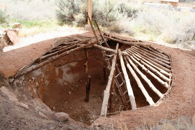
Safely making our way to Boulder, we stopped at the Anasazi State Park Museum. The park is located at the site of one of the largest Ancestoral Puebloan communities west of the Colorado River, thought to be occupied from the years 1050 to 1200. We first toured the museum, where there is an excellent collection of pottery and other artifacts uncovered at the site. Charlotte got to try some hands-on projects, such as making a few rubbings of pottery designs.
Outside the back door we toured the grounds that contained the Coombs Site ruins, where excavations large and small have been conducted intermittently since 1927. Only half the site has been examined, but it has been found to contain 97 rooms, 10 pit structures and thousands of artifacts.
From Boulder to the end of the byway, the road has been paved only since 1985. An undulating segment takes you through miles and miles of aspen groves and through dense forests of pine around Boulder Mountain. This is one of the top places in the West for fall foliage season. In late spring we found choice, far-reaching views to the east from signed overlooks. Homestead Viewpoint was our favorite; from there we could see the Henry Mountains and into Capital Reef National Park. The day of our visit wasn't crystal clear, but on a perfect day, it is said, one can see more than 100 miles, into Arizona and even Colorado.
The Byway ends in Torrey, the gateway to Capital Reef National Park, whose main entrance lies just miles to the east along another scenic byway. The park was established to protect geologic grandeur and pioneer history. Its most prominent feature is Waterpocket Fold, a 100-mile wrinkle in the earth's crust. We spent most of the afternoon hiking short trails in the park, including one that leads to Hickman Bridge. Geologically speaking, bridges are formed by waterways, and are rarer than arches. This one spans 130 feet and is 125-feet high.
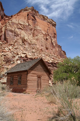
From there, we headed to the Fruita section of the park. Fruita was a pioneer community first settled in 1880, and fruit orchards were planted at the time for personal use and to barter with others for needed goods. We visited the restored schoolhouse and the Historic Gifford Homestead, which affords a feast not only for the intellectually hungry but for those with ordinary outdoor appetites. Charlotte and I feasted on homemade vanilla ice cream, forgetting to leave room for the freshly baked pies that are also available.
The Park Service now owns and maintains the Fruita Orchards, holding about 2,600 trees, primarily cherry, apricot, peach, pear and apple. There are also a few plum, mulberry, almond and walnut trees. In-season visitors are allowed to pick ripe fruit. Hand-held fruit pickers and ladders are available and bags, scales and self-pay stations are provided. Furthermore, any fruit you eat while picking, is free. Starting around mid-June, you can expect cherries to be ripe, followed by overlapping harvests of apricots, peaches and pears throughout the summer and early fall. It's over in October with the last of the year's apple crop.
To be considered for the title of an All-American Road, a route must have at least one of six essential values -- recreational, scenic, natural, archeological, cultural or historic. This road scores about seven out of six. I give an extra point for peaches.
Contact Deborah Wall at deborabus@aol.com.
GETTING THERE Location: National Scenic Byway 12 in Southern Utah, beginning about 225 miles from Las Vegas and traveling 124 miles from Red Canyon to Torrey. Directions: From Las Vegas, take Interstate 15 north 125 miles and take Exit 16 (Hurricane/Zion National Park). Follow Route 9 for 57 miles through Zion National Park and turn left at Mount Carmel Junction onto U.S. 89. Go north 43 miles and turn right onto Scenic Byway 12. Byway 12 Lodging: Best Western Ruby's Inn, Bryce Canyon, (800) 468-8660, www.rubysinn.com; Bryce Canyon Lodge, Bryce Canyon National Park., (888) 297-2757, www.brycecanyon lodge.com; Escalante Outfitters and Bunkhouse, Escalante, (866) 455-0041, www.escalante outfitters.com; Circle D Motel, Escalante, (435) 826-4297, www.escalantecircled motel.com; Best Western Capital Reef Resort, Torrey, (435) 425-3761, www.bestwestern.com; Austin's Chuckwagon Lodge, Torrey, (800) 863-3288, www.austinschuck wagonmotel.com. Red Canyon: Managed by Dixie National Forest. The visitor center is open daily through September 9 a.m.-6 p.m. with shorter hours, fewer days, fall through spring. (435) 676-2676, www.fs.fed.us. Bryce Canyon National Park: Open daily year-round. Visitor center open daily 8 a.m.- 8 p.m. in summer, shorter hours fall through spring. Closed Thanksgiving and Christmas. Two developed campgrounds available first-come, first-served. (435) 834-5322, www.nps.gov/brca. Utah State Parks: Escalante Petrified Forest State Park, Escalante, (435) 826-4466; Anasazi State Park Museum, Boulder, (435) 335-7308, www.stateparks.utah.gov. Grand Staircase Escalante National Monument: Escalante Interagency Visitor Center, 755 West Main St. (Byway 12). Open daily 7:30 a.m.-5:30 p.m. through November with shorter hours in winter and spring. Developed and primitive camping. (435) 826-5499, www.ut.blm.gov/ monument. Capital Reef National Park: Open daily year-round. Visitor center open daily 8 a.m.- 4:30 p.m. Closed Christmas. One developed campground and two primitive campgrounds, all first-come, first-served. (435) 425-3791, www.nps.gov/care. National Scenic Byway 12: www.scenicbyway12.com.


