Drones over public land
Whenever the federal government finds a way to spend less taxpayer money, it’s worth heralding. Such is the case with a relatively new program utilized by the U.S. Geological Survey involving unmanned aircraft — better known to the public as drones.
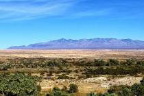
The USGS started using drones for wildlife and land management about two years ago, and the technology will make its way to Southern Nevada by summer’s end. The aircraft will be used to count bighorn sheep and deer within the Desert National Wildlife Refuge north of Las Vegas.
The savings are significant. To this point, counting such wildlife required sending people up in a helicopter, at a cost ranging from $20,000 to $40,000 per trip, said Mike Hutt, who heads up the USGS National Unmanned Aircraft Systems Project Office in Denver. This technology allows cash-strapped field offices to do the same work for as little as $3,000, mostly in labor expenses. USGS personnel use five-pound planes that are no bigger than a turkey vulture, or 18-pound helicopters. The devices have minimal maintenance and operational costs.
Imagine the dent Washington could make in the budget deficit and national debt if every agency lopped 85 percent or more off the cost of their work. But the Interior Department could save the public even more money here.
Speaking to privacy concerns, Mr. Hutt noted that drones rarely fly over private property. That will surely be the case in Nevada, because the federal government owns about 85 percent of the Silver State’s land.
So here’s an even better idea: Forget about drone management and counting critters. Sell off a bunch of that land to private owners, who could then manage it at no cost to taxpayers while allowing Nevada’s counties to collect property taxes on the acreage. And that USGS building in Denver could get a new name: The National Unmanned Office.