
Google Maps dives under the sea


Not content with mapping the world’s streets, Google is taking to the ocean.
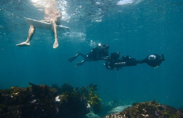
Divers with underwater scooters have descended upon Sydney to film test footage from the bottom of the city’s well-known harbor.
The team of divers will spend eight months capturing footage from the bottom of the harbor and the waters off the coast of Bondi and Manly beaches. When the full footage is unveiled, Google is hoping it will reach at least 1 billion people.
The project, a joint effort by Google and the Catlin Seaview Survey, will do more than let the world take a peek under the sea, though. Officials are hoping the survey will provide a scientific baseline to monitor changes across the area and highlight hot spots for debris and pollution, according to the Sydney Morning Herald.
“The downside of being a city harbour is that it’s subject to a range of threats from debris and rubbish,” Professor Emma Johnston with the Sydney Institute of Marine Science told the Herald. “In one spot, there was two shopping trolleys, a bicycle and bathtub.”
The images showcase the beauty and diversity of marine life, Johnston said.
“We tend to think of the harbour as a monolithic and flat surface, but people will be blown away by what is happening underneath; the amazing kelp forests, underwater gardens of sea tulips and sponges and fish that they have never seen,” she said. “The diversity of sea life is greater than any harbor in the world.”
Google has made a major push in recent years to make available imagery from famous or unique locations around the world, although usually those locations are above-ground. The company has recently released Street View footage of hiking trails, parks and beaches in Hawaii; the remote Canadian tundra; and the Taj Mahal, among other landmarks.
Contact Stephanie Grimes at sgrimes@reviewjournal.com. Find her on Twitter: @stephgrimes


