
Cerca: Death Valley treacherous but starkly beautiful


Coffin Peak. Last Chance Mountain. Deadman Pass. Dry Bone Canyon.
If these corners of Death Valley National Park make the place sound foreboding, well, that's because it is. Death Valley is one of the world's hottest, driest spots. Many of the park's features earned names from the misfortunes of hardscrabble pioneers headed through the valley toward California, or from descriptions of harsh life recorded by miners who camped there in the early 1900s to scratch the hard-packed earth for borax and gold.
Despite their trials, those early pioneers recognized the area's desolate beauty. Resorts had popped up in the valley by the late 1920s to accommodate tourists who wanted to experience the park's climatic and topographic extremes, from the hot, lunar landscapes of Devil's Golf Course on the east side to the lush, cool mountainsides of Wildrose and Telescope peaks on the west.
Today, as nearly 100 years ago, the best time to take in those sights kicks off in fall, when Death Valley's unforgiving summer heat relents to cooler daytime temperatures in the 70s and 80s. And with Death Valley right in Southern Nevada's backyard - its east-central border juts into Nevada west of Beatty - the park is an ideal trek for locals looking for a quick day trip or an overnight backpacking adventure.
If you have only a day to visit, stick with Death Valley's east side, an easy two-hour drive from Las Vegas and home to some of the park's most striking attractions. You can get a taste for the park and its offerings in a little more than half a day.
WHEN TIME IS SHORT
Our latest trip to Death Valley, in early October, started where every journey to the park should begin: on the east side at Dante's View, a mile-high lookout in the Amargosa Mountains that offers a panoramic look at the park's basin-and-range layout.
Heading west toward the park on California Route 190, the turnoff for Dante's View, on the left, is the first Death Valley attraction you come to. A winding, 13-mile road takes you to the lookout 5,475 feet above sea level. Directly below is the salty plain of Badwater, the lowest spot in North America, at 282 feet below sea level. Straight ahead, across the valley, are the Panamint Mountains. Northwest of the Panamints, you can see the 14,505-foot Mount Whitney, the highest peak in the lower 48 states.
Dante's View is always windy and cool, and the morning we visited was no exception, with a temperature of about 50 degrees just after sunrise and gusts strong enough to push us along the mountaintop trail. Take a windbreaker and be prepared for temperatures a good 25 degrees cooler than the valley floor.
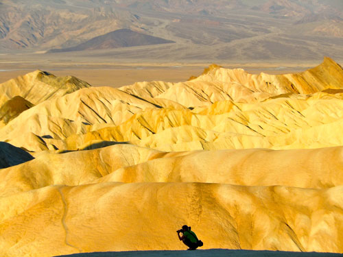
After you've taken in Dante's View, head back down the mountain and continue west seven miles on Route 190 to Zabriskie Point, one of Death Valley's most popular features. The point's undulating bands of golden, tan and red badland hills, carved over eons by water flow from occasional but fierce rainstorms, lure dozens of photographers at sunrise and sunset. The view is a short but steep walk up a paved trail from the parking lot. Directly in front of you is the back end of Golden Canyon, the first in a series of must-sees lining Badwater Road, one of the valley's main byways.
To reach the road, head northwest from Zabriskie Point on Route 190, about two miles. Then, turn south on Badwater Road to enjoy a 17-mile stretch of stops at relatively easy trails to about half a dozen natural wonders.
At Golden Canyon, a mostly level hiking trail takes you a little more than a mile to a view of Red Cathedral, a mahogany-colored cliff with fluted walls that look like church organ pipes. Iron oxidation - essentially, rust - gave the cathedral its red-brown hues.
For colors of a different sort, make Artist's Drive your next stop along Badwater Road. The one-way, nine-mile paved road shows off an otherworldly blend of red, green, pink and purple hillsides, tinged as iron, manganese and other products of volcanic activity oxidized more than 5 million years ago.
About three miles south of Artist's Drive, a one-mile dirt road skirts off to the west, to Devil's Golf Course. At the road's end is a 3-foot-thick expanse of craggy, sharp salt crystals formed as floodwaters evaporated and left behind minerals. It rains less than 2 inches a year in Death Valley, so it can take more than 30 years for the delicate salt spires to grow an inch. Watch your step here - the broken ground is uneven, and it's easy to trip or twist an ankle if you don't look where you're going. (Don't confuse this area, a golf course in name only, with the actual golf course at the Ranch at Furnace Creek.)
A mile south on Badwater Road, this time on the left, is another notable valley landmark. Take the one-mile dirt road to the Natural Bridge Canyon parking area, and follow the gravelly but mostly level trail for a third of a mile to the 50-foot natural rock bridge that arches over the path. As with so many of Death Valley's geological phenomena, the bridge was hewn over thousands of years by floodwaters, which undercut the rock and left a gaping cavity beneath the hillside.
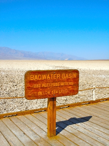
About four miles south of Natural Bridge Canyon is Badwater, the perfect final Death Valley destination for day-trippers. As at Devil's Golf Course, evaporating rainwater created saline deposits at Badwater, but the spot's record-low elevation draws floodwaters that sand the salt to a smooth finish, unlike the jagged surface at Devil's Golf Course.
Badwater is one of Death Valley's hottest destinations, literally and figuratively. On the early October morning we visited, it had climbed to nearly 90 degrees in late morning. At nearby Furnace Creek, the world's highest-ever recorded temperature of 134 was reached in July 1913. The valley's average July temp is 115, but park officials say the salty floor around Badwater can surge toward 200 degrees. By October, the daily mean air temperature has fallen to 92, yet we could still feel warmth radiating up from the broad, briny path at Badwater.
The heat didn't prevent busloads of tourists from stopping to take pictures of themselves with signs marking the elevation. In all seasons, including summer, Badwater is one of the busiest spots in the park, so be prepared for crowds. Also, stick to the boardwalk and trail to protect tiny snails and insect larvae that live in the brackish soup at Badwater.
The heat and blazing sun made us think of the tribulations of pioneers, who had to survive the valley without the comfort of air-conditioned cars and buses or the security of nearby hotels and restaurants. It also gave us an appreciation for the Timbisha Shoshone, the valley's native tribe, whose people have thrived in the area for thousands of years. The tribe has a reservation in Death Valley next to the Ranch at Furnace Creek.
Double back toward Furnace Creek, about 17 miles north of Badwater, if a busy morning of hiking and sightseeing has left you hungry. The upscale Inn at Furnace Creek has expansive views of the valley floor from its dining room, but its higher-end atmosphere doesn't allow shorts, T-shirts or tank tops. For casual dining, head across the road to the Ranch at Furnace Creek, which has a cafe, a breakfast and lunch buffet, and a saloon that serves bar food.
Furnace Creek, Stovepipe Wells Village, at the park's center, and Panamint Springs, on its west side, all have accommodations if you decide to extend your stay overnight to go deeper into the park. Planning a visit to the park's interior can be well worth the effort if you're looking for a little solitude.
LONGER VISIT
Death Valley is the largest national park in the lower 48 states, at 3.4 million acres, but it attracted just 867,255 visitors in 2011. By contrast, Lake Mead National Recreation Area's 1.5 million acres draws about 8 million guests a year. The 195,819-acre Red Rock National Conservation Area hosts more than 1 million people annually.
But the corners of Death Valley with the fewest people are as far as 60 miles away from Furnace Creek and Badwater, and getting to those quieter spots usually requires slow-going travel on miles of rugged dirt roads. That's why an overnight trip is the best way to see the park's lesser-visited highlights.
Make your first stop in the park's interior at Mosaic Canyon, just west of Stovepipe Wells Village in the park's midsection. The quarter-mile hike to the canyon's narrows is easier than the rough, two-mile drive to its mouth, particularly if you don't have a four-wheeler. As soon as you enter the canyon, its smooth, marbled walls close in: Extend your arms out and touch both sides of the canyon in parts. The canyon's swirling, multicolored rocks originated 900 million years ago, when the area was part of the Pacific Ocean.
Mosaic Canyon is fairly open and can warm up quickly once the sun rises. For a dramatic change in scenery and some cooler temperatures, head west out of Mosaic Canyon and drive eight miles to Emigrant Canyon Road and the turnoff to Wildrose. A paved but winding 25-mile road takes you to several features: a row of abandoned, 25-foot charcoal kilns used in mine smelters in the late 1800s; the 9,064-foot Wildrose Peak; and Death Valley's tallest point, the 11,049-foot Telescope Peak.
From the charcoal kilns, the hike to Wildrose Peak is 8.4 miles round-trip with a 2,200-foot elevation gain, but hiking just two miles up the trail gives you panoramic views of Death Valley to the east. The tougher Telescope Peak hike is 14 miles round-trip, and gains 3,000 feet on the ascent, with a pretty meadow in the middle. The National Park Service tells visitors to allot nine hours for the Telescope hike, but as with Wildrose, a shorter trek up the trail dazzles with broad views into canyons below. Both peaks can become impassable in winter and spring, so go soon if you want to see these trails before the end of the year.
So we've seen colorful badlands, windblown alpine peaks, earthquake-formed canyons and sub-sea-level lake beds. But Death Valley's not done showing off its extremes. For one last desert surprise, hop back on Route 190 and drive west about 23 miles from the Wildrose turnoff, through the Panamint Range. Pass through Panamint Springs to come almost immediately to the road to Darwin Falls, on the left. The 2½-mile road is rough, but passable for most passenger cars if you take it easy.
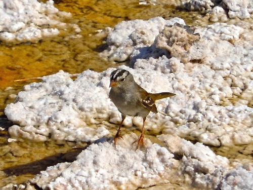
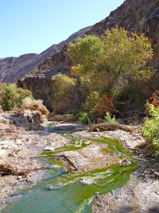
From the parking area, find Darwin Creek and follow it on foot. You'll have to cross back and forth over the creek to track it, but the burbling stream was just a foot wide in most places when we visited, and our feet never got wet. After a mile of mostly level walking past thickening, lush stands of willow and cottonwood trees, we came to Lower Darwin Falls, a 25-foot, spring-fed double waterfall that serves as the only year-round water source in the west-central part of Death Valley. The water and the trees support dozens of varieties of birds, including swallows, flycatchers and prairie falcons.
The 140-foot Upper Darwin Falls are another tenth of a mile beyond the lower falls, but getting to the triple waterfall requires scrambling over slick, wet granite boulders. We ended our trip at the lower falls.
Just how isolated are the park's central and west sectors? On the early October weekend we visited, we saw three other visitors in Mosaic Canyon and two other families at Wildrose. We had Darwin Falls all to ourselves, with only butterflies and cliff swallows circling overhead to keep us company. But it was still hot, with highs of about 100 each day, and traffic at the park picks up significantly as temperatures cool from November through February. Still, no matter the time of year, you'll find far fewer fellow hikers if you venture beyond Badwater Road.
Keep a few precautions in mind, though. Be prepared for flat tires, no matter where you go. The roads to many Death Valley attractions consist of rough, dirt trails strewn with big rocks. Cellphones don't work in most parts of the park, and a tow from a back road can be prohibitively expensive. For the same reason, make sure you never run out of gas. There are three stations inside the park, at Furnace Creek, Stovepipe Wells Village and Panamint Springs.
Also, we didn't have time in two days to see the park's northern sites, including Scotty's Castle, Death Valley's only mansion, or Ubehebe Crater, a 770-foot hole caused by a steam explosion. Also in the north is the Racetrack Playa, where boulders mysteriously move by themselves across a dry lake bed, leaving furrows in the earth. If you want to visit the playa, park officials insist you drive a four-wheeler with heavy-duty tires, because the 25-mile dirt road is littered with sharp rocks.
Once you're ready to head back to Las Vegas, consider taking the Old Spanish Trail Highway for a glimpse at the path pioneers traveled from New Mexico to California, and to see a working date ranch in the desert.
Take Route 190 east or Badwater Road south to California Route 127 and head south. Five miles past Shoshone, turn left on Hot Springs Road. To visit China Ranch Date Farm, which sells date products, including bread, cookies and milkshakes, follow the signs to a well-graded dirt road that winds through a canyon and leads to the verdant ranch. In addition to its store, China Ranch has a small museum and hiking trails. To continue on your way to Las Vegas, turn right, or east, when you get back on Old Spanish Trail Highway coming out of China Ranch.
Whether you have a day or a long weekend to explore, the Death Valley countryside has sights for you to see. Plan accordingly, and your trip can be considerably safer and more enjoyable than the experiences of the pioneers who traveled through a century ago.
Contact reporter Jennifer Robison at jrobison@reviewjournal.com or 702-380-4512. Follow @J_Robison1 on Twitter.
If You Go
LOCATION: Death Valley National Park is about 120 miles west of Las Vegas in California.
DIRECTIONS: Shortest route (two hours) - From Interstate 15, exit west on Nevada Route 160. Drive 60 miles to Pahrump, and turn left on Bell Vista Road. Drive 30 miles to Death Valley Junction, Calif. Turn right on California Route 127, and make a quick left on California Route 190. Drive 20 miles to the Furnace Creek Visitors Center. Scenic Route (3 1/2; hours) - Take I-15 and exit west on Nevada Route 160. Drive 45 miles and turn left on Tecopa Road, which is the Old Spanish Trail. Drive 41 miles, and turn right on California Route 127. Drive 10 miles and turn left on California Route 178 West (Badwater Road). Drive 75 miles, and turn left on California Route 190. Drive one mile to the Furnace Creek Visitors Center.
LODGING: The Four Diamond, 66-room Inn at Furnace Creek, and the 224-room Ranch at Furnace Creek, 760-786-2345; Stovepipe Wells Village, 760-786-2387; Panamint Springs, with 14 rooms and one cottage, 775-482-7680. All resort areas have gas stations, restaurants, general stores, campgrounds and RV sites. All accommodations are on California Route 190.
CAMPGROUNDS: Texas Spring, at sea level just northeast of Furnace Creek, has 106 sites and charges $14 a night. Mesquite Spring, at 1,800 feet and near Scotty's Castle in the north, has 40 sites and costs $12 a night. Emigrant, eight miles west of Stovepipe Wells on Route 190, is at 2,100 feet, has 10 sites and is free. Wildrose, near Wildrose Peak, is at 4,100 feet, with 23 sites, and is free. Thorndike and Mahogany Flat are both above 7,000 feet, near Telescope Peak, and have a combined 16 sites, with no nightly fee. Campgrounds at the park's three resort areas range from $7.50 to $32 a night. Death Valley camping
FOUR-WHEEL RENTALS: Farabee's Jeep Rentals, Furnace Creek Inn, 760-786-9872.
DEATH VALLEY NATIONAL PARK: Furnace Creek Visitors Center. National Park Service-operated facility offers park information, ranger talks and details on campgrounds and trail conditions. A $20 park pass is good for as long as seven days, 760-786-3200. Death Valley park information


