After 40 years, Glen Canyon Dam still inspires awe
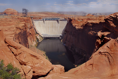


I look up, then I sit down. Staring up the 583-foot face of Glen Canyon Dam from its base is a dizzying experience. At least for me. It sends my equilibrium spinning. I'm standing, or rather sitting, on two acres of grass at the bottom of the dam, last stop on a guided tour of Glen Canyon Dam.
As soon as I arrive at the Carl Hayden Visitor Center that is center-perched on the edge of Glen Canyon Dam, I head to the reservation desk to put my name on the tour list. No advance reservations are accepted and the tours fill quickly.
The east wall of the visitor center is glass, floor to ceiling. From this viewpoint, I can see the dam, Glen Canyon Bridge, Colorado River and Lake Powell. It's a jaw-dropping view. But the actual construction of the dam and bridge is just as mind-boggling.
In 1956, when Congress authorized building a dam on the Colorado River for flood control and power production, Glen Canyon was almost inaccessible. Only intrepid river rafters saw this portion of the river. In 1879, explorer John Wesley Powell made his epic boat tour down the Colorado River and wrote: "On the walls, and back many miles into the country, numbers of monument-shaped buttes are observed. So we have a curious ensemble of wonderful features -- carved walls, royal arches, glens, alcove gulches, mounds and monuments. From which of these shall we select a name? We decide to call it Glen Canyon." It is ironic that Powell also suggested that this would be a good spot for a dam.
The government wasn't so poetic when they chose the dam location. Criteria were simple: 1) A site for an immense lake. 2) Stable canyon walls and bedrock (no earthquake faults.) 3) A close source of aggregate for cement. At this point, Glen Canyon was narrow, meaning less construction costs, and the decision was made, even if the site was a long way from anywhere.
Not everyone was happy about the new dam. Environmentalists decried the flooding of beautiful canyon country and ancestral Pueblo sites. Those clamoring for the dam claimed it would open up the backcountry to recreation and control downstream flooding. Besides, the growing Southwest needed the electricity. Even now, 50 years later, the arguments still go on with some wanting Lake Powell drained.
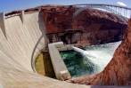
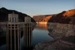
In the visitor center, I peruse the displays, watch a video on the dam construction and browse the bookstore until the tour is called. I board the elevator, descending 110 feet to the level of the dam and walk out on its crest, 1,560 feet long and 35 feet wide. Eight small buildings perch on the upstream side of the dam. The guide explains these contain "penstocks," each a 15-foot diameter steel tube, 500 feet long, which carries water from the lake to a turbine inside the power plant.
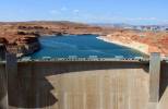
The dam holds back Lake Powell, named after the 19th-century explorer. The second largest man-made lake in the United States, it has as much shoreline as the United States' entire western seacoast. When completely full, Lake Powell is 568 feet deep and holds 10 trillion gallons of water. That's enough to cover the state of Arizona with five inches of water. Because of drought, the lake is down about 100 feet, exposing a 100-foot-wide, white "bathtub ring" along the shoreline.
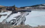
A rusty bucket that held 24 tons of damp concrete sits on the dam crest, a reminder of construction days. It took 400,000 bucket loads, working continually, 24-hours-a-day from June 1960 to September 1963, to pour 4,901,000 cubic yards of cement in the dam. Since the concrete needed to be a certain temperature, shaved ice was added to the mix. This called for the world's largest ice plant to be built nearby. Lady Bird Johnson dedicated the dam in September 1966.
The next elevator goes down 528 feet inside the dam. I try not to think about all that water just behind the wall. Humming right along, eight hydroelectric generators produce 1.3 million kilowatts of electricity. A digital computer, with numbers flashing, registers how much money is earned from the sale of all that electricity to 1.7 million people.
Last tour stop is the Powerplant Transformer Deck, where I sit down on a grass area the size of two football fields and get a crick in my neck looking up at Glen Canyon Dam, the second highest concrete arch dam in the United Sates. Hoover Dam is 16 feet higher, but from this angle, I can't see much difference. Turning around, though, gives me another impressive sight. The Glen Canyon Bridge.
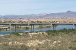
The steel arch bridge is 700 feet above the Colorado River and the deck is 1,271 feet long. It took two years to build, but it was worth it. Before bridge completion, it was a 200-mile trip to get equipment from one side to the other. Workers crossed over on a swinging footbridge 700 feet above the river. Imagine crossing that when the wind was blowing at a good clip. I would have had to crawl across with my eyes closed.
About 45 minutes from the time I stepped out on the dam, I'm back in the visitor center and ready to cross the Glen Canyon Bridge -- thankfully not a footbridge any more -- and head into Page. The town's 7,000 residents are still celebrating the 50th anniversary of what started in 1956 as Camp Page, a temporary home for construction workers.
Manson Mesa, the windblown tableland where the town sits, was the grazing allotment of the Manson Yazzie family. The Navajo Nation traded 17 square miles of tribal land for what is now the Aneth Oil Fields in southeastern Utah. At first, Camp Page was just rows of trailers with mini-laundromats at the end of each row. Residents took turns doing their laundry because of the limited number of washing machines.
Named after John C. Page, Bureau of Reclamation commissioner during FDR's administration, Camp Page soon became just Page and the start of a planned community. Eleven religious denominations were given land for church buildings on the east side of Seventh Avenue and the area is known as "Church Row." The school buildings are right across the street from the churches. At first all the motels and restaurants were in one area, up on the mesa, but with 2 million visitors a year, the town is spilling down to the flats below.
When construction workers left after completing the dam in 1964, Page's population dropped drastically, but the Navajo Generating Station, a coal-fired plant completed in 1970, brought in new workers. The plant, just east of Page on the Navajo Reservation, sends electricity throughout the West. Today tourism, the power plant and jobs connected with the dam, drive the economy.
The Lake Powell National Golf Course, a public course, is arguably one of the most beautiful golf courses in the Southwest. The 18-hole-course is built up against the undulating red sandstone cliffs and is open year round.
To get the best overall history of the town, visit the John Wesley Powell Museum. The museum documents Powell's two historic trips down the Colorado River in 1869 and 1871, and also displays the town's history, archaeology, geology and movies made in the area. Kids love the exhibit of rocks that glow under a black light.
At the John Wesley Powell Museum, you can book activities such as Jeep or Hummer trips, scenic air flights, horseback or mountain bike riding, raft trips and boat trips on Lake Powell, or a trip to Antelope Canyon, a spectacular slot canyon on the Navajo Reservation. Brochures for the many hiking and biking trails are also available. The eight-mile Loop & Rim View Trail circles the city, the 1.5-mile Horseshoe Bend Trail leads to an overlook of a tremendous curve in the Colorado River, the Wahweap Overlook, a short distance from the Hayden Visitor Center, is a favorite spot for sunrise and sunset views.
Lazily, I take my view of the sunset from my hotel window. The red buttes glow against the blue waters and the white dam is clearly visible. Thank heavens. Finally, a view of the dam that doesn't make me dizzy.
GETTING THERE
Location: Page, Ariz., 274 miles east of Las Vegas.
Directions: From Las Vegas, take Interstate 15 north 126 miles to Exit 16/Utah Route 9. Head east 10 miles to Hurricane, Utah, then southeast on Utah Route 59 East for 24 miles to Hildale, Utah, on the Arizona border. Here, Utah 59 becomes Arizona Route 389. Go 33 miles to Fredonia, Ariz., then north on U.S. 89A seven miles to Kanab, Utah. Turn east at Kanab on Utah Route 89 for 74 miles to Page.
Best time to visit: Best weather is mid-March to mid-May and mid-September to November, but attractions are open year-round.
Carl Hayden Visitor Center: Opens 8 a.m. daily except major holidays; closes at 6 p.m. from Memorial Day to Labor Day. In the nine cooler months, closes at 4 or 5 p.m. depending on staffing. Arizona does not use Daylight Savings Time. (928) 608-6404, www.nps.gov/glca, www.pagelakepowelltourism.com.
Glen Canyon Dam Tour: Free, given seven days a week except Thanksgiving, Christmas, and New Year's Day, but may close for maintenance, inclement weather, or high national security level. Call center for current hours of departure. No reservations taken, so sign up as soon as you arrive at visitor center. Group tours (parties over 10) available by prearrangement; (928) 608-6072; www.glencanyon.org.
Book tours to other attractions at: John Wesley Powell Museum: 6 N Lake Powell Blvd., (928) 645-9496, www.powellmuseum.org.
Accommodations: Days Inn & Suite, 961 N. Highway 89, (928) 645-2800, daysinn@thedam.com; Best Western Arizonian, 716 Rimview Drive, (928) 645-2466; Courtyard Page, 600 Clubhouse Drive, (928) 645-5000.