Off the Beaten Path in Utah


One of the great delights of traveling to Utah's Capitol Reef National Park is the journey itself.
While I find all of rural Utah enchanting, a drive along Scenic Byway 12, the preferred route to the park, has to be one of the most picturesque motor trips in the nation. Earlier this summer, my daughter Charlotte and I got reacquainted with this 124-mile road and its attributes, which have earned it the distinction of being an All-American Road.
This designation is awarded by the U.S. Secretary of Transportation and is so prestigious, there are only about three dozen in the country. To receive such a title, the road must have multiple characteristics, the most important of which is it must be considered a destination unto itself. Visitors won't be disappointed with a trip here as the byway boasts scenic, natural, cultural, historic, recreational and archaeological values.
It was still early morning when we started our adventure, turned onto the start of Scenic Byway 12, heading east from U.S. 89 just south of Panguitch.
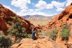
Our first stop was just a few miles up the road at Red Canyon, where we walked among the pink and orange natural pillars called hoodoos -- a hint of what was to come farther ahead at Bryce Canyon National Park. Here are an excellent museum and some of the best mountain biking trails of the region, including the famously challenging eight-mile Thunder Mountain Trail. It was hard not to spend the day there, but we still had many miles to go, so off we headed east.
Just 10 minutes later, we were up on the Paunsaugunt Plateau and nearing Bryce Canyon National Park. Even if you have limited time, it's worth standing on the rim and looking down into the sea of hoodoos that fills the park's natural amphitheaters.
The byway is dotted with small towns, most established by Mormon pioneers. Our favorite is Escalante, originally a little ranching burg that has become of international importance to outdoor lovers, who use it as a jumping-off place for the remote backcountry of the 1.9 million-acre Grand Staircase-Escalante National Monument. The Escalante Interagency Visitor Center is located in town, and there are several places to get a room for the night, camp, grab a bite to eat or stock up on supplies.
Charlotte and I have stayed in Escalante many times in order to get an early morning start on hikes into the famous canyons of the Escalante River. Such excursions allowed us to explore some of the most stunning and remote territory in the Southwest. This time, we stopped only briefly at one of our favorite places in town, Escalante Outfitters. This establishment offers quality outdoor gear, cabins, campsites, a cafe, area maps, and the only package liquor store on the byway. It also provides access to the Internet and, quite important, a phone booth. Cell phones are unreliable along Scenic Byway 12.
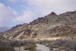
Returning to the road and heading east out of Escalante, about a dozen miles or so later, we descended through the slickrock terrain called "The Head of the Rocks." The road through this rugged section was built by the Civilian Conservation Corps in 1935, opening up access to that area, but it wasn't until 1971 that it became paved.
The road wound down to and over the Escalante River, one of the main drainages in this area, and one that empties into Lake Powell some 70 miles downstream. So remote is the Escalante that in 1866, it was the last good-sized river in the contiguous United States to be discovered by its non-native citizens. We have hiked many segments of the stream before, including two hikes that began at this crossing. On one of those hikes, in the space of one day, we saw a lush riparian habitat, a nice natural arch, a couple of granaries built centuries ago by American Indians, a bobcat, a scorpion and about a dozen turkey vultures.
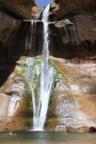
On this trip, our next stop was about a mile away at Calf Creek Recreation Area, where we enjoyed a six-mile round-trip hike to lower Calf Creek Falls. The trail passes pictographs -- three human figures painted long ago on the sheer cliff of Navajo sandstone. We walked upstream past marshes created when beavers dammed the creek. The stream is perennial, and the trail climaxes when you turn a corner into a box canyon and are overwhelmed by the sight and sound of a 125-foot waterfall plunging into a lovely blue-green pool. Surrounded by shade trees and small sandy beaches, this pool does not merely invite a swim, but demands it. We welcomed the chance to cool off and play. It was hard to tear ourselves away from such a beautiful and remote place, but we needed to get back on the road.
The elevation at the trailhead is about 5,300 feet, so, much as we enjoyed our summer visit, this trip is better taken in April, May, September or October, when the weather is cool enough for easy hiking but not too cold for a dip in this enchanting pool. It's an exposed hike, so bring plenty of water and a hat. And a bathing suit.
This entire area is rich in history, but along Scenic Byway 12 it is best highlighted at the Anasazi State Park Museum in Boulder. The museum is located on the site of one of the largest Ancestral Puebloan communities west of the Colorado River, thought to have been occupied from 1050 to 1200. Part of the site is the Coombs Site Ruins, which contains 97 rooms and 10 pit structures. This ongoing excavation project, started in 1927, has so far examined only half of the site. That makes it an especially good site to visit, for you can see not only what such a place looks like after it's excavated, but what it looks like still bearing the overburden of 800 years of abandonment.
Leaving Boulder, the highway gains plenty of elevation as it approaches Boulder Mountain. Here, you find miles and miles of dense mostly evergreen forest, spangled with aspen groves that glow yellow in the fall. The display begins about mid-September and lasts through mid-October, depending on the weather.
Several overlooks along this section offer far-reaching views of rugged territory to the east. At the Homestead Viewpoint, you get one of the best bird's-eye views into the Henry Mountains and Capitol Reef National Park. This is a good place to view its most famous geological feature, the 100-mile wrinkle in the earth known as the Waterpocket Fold.
The road then descends into the picturesque town of Torrey, the end of our journey yet the gateway to Capitol Reef National Park. Our next two days were spent entirely in the park, the evenings devoted to relaxing in our small cabin at Austin's Chuckwagon Motel. This is not a fancy place but a very clean and convenient one, with a small kitchen and within walking distance of a few small restaurants, a couple of stores and the many historic homes in the town.
Torrey's historic homes are relatively small structures, some of wood and some of stone hewn from the hills. There's at least one building of logs, which served as both church and school in the late 1890s. Each house stands in its own lot with space for a kitchen garden and mature trees that have grown so big, it's as if the whole downtown grew a canopy.
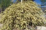
Our park visit started at Fruita, the main area of the park. This once was a farming community settled in the 1880s on the banks of the Fremont River and surrounded by sandstone cliffs, mesa and natural domes. The settlers planted fruit trees for their own use and also to barter the fruit for whatever else they needed. To water their orchards, they built an irrigation system, some of which still serves that purpose today.
The park service owns and maintains 2,600 trees -- apple, apricot, cherry, peach, pear, plum and a few nut trees. From June to October, visitors can pick the ripe fruit. Hand-held pickers, handy devices like small baskets built onto the ends of long poles, as well as ladders, bags and scales, are provided. Self-pay stations operate on the honor system, and any fruit you eat while picking is free. Peaches and pears are ripening as we speak and usually can be picked through the beginning of September; apple season starts about the first week of September and often extends to mid-October.
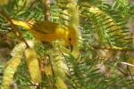
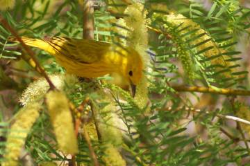
Our second day in the park was spent hiking a variety of trails, including a relaxing stroll along the Fremont River Trail, where we unexpectedly encountered a big flock of northern orioles socializing in four or five fruit trees along the river. This was a treat, for northerns are the most colorful of all orioles. Males are bright orange and black. Instead of the drab dresses favored by most songbird females, lady orioles wear yellow breasts and white bars on their gray wings. Both genders looked very handsome against the green foliage, and they let us get close enough to admire them. We would come within 20 feet or so before they fluttered to some other branch. It was the largest gathering of orioles I had ever seen, and I could hear their noisy party for some distance after I passed.
We followed the river about a mile or so and then headed up to an overlook with views into the valley below. Next, we headed out the main road east through the Fremont River Canyon, where we hiked a few miles along the Grand Wash Trail, which had a wonderful narrows section. Just a few miles east of there, we topped off the day with a refreshingly cold dip into a deep pool of water beneath a 20-foot waterfall.
Our adventures were all in summer, but I couldn't help thinking that autumn might be the ideal time to visit this park. In September, the average daily high is 81 degrees and the low 53; in October, the average high is 68 with average lows of 42.
That's apple-picking weather for sure.
Contact Deborah Wall at deborabus@aol.com.