Winter paves way for trip to Fortification Hill

If you're one of the smart hikers who keeps a list of seasonal hikes - those that should be attempted only at some particular time of year - Fortification Hill should be near the top of your winter list.
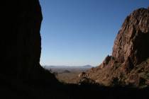
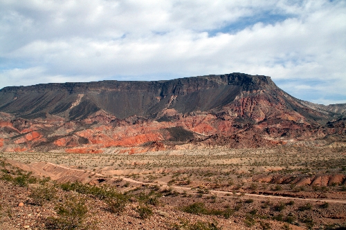
Located in Arizona just east of Hoover Dam, it's too hot and exposed to sun to be any fun in the warmer months. But in winter, it offers enough challenges and exercise to justify a sense of accomplishment upon reaching the summit, where you'll also be rewarded with one of the finest views to be had in the Lake Mead National Recreation Area.
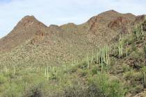
The "hill" is really a mesa formed through hundreds of volcanic episodes occurring more than 5 million years ago. Towering 2,000 feet over Lake Mead's Boulder Basin, it appears nearly unclimbable at first glance, but from the trailhead on its southeast side, it's merely strenuous.
Even so, this hike isn't for small children or anyone who isn't up for some dangerous rock scrambling through the basalt cliffs and tackling scree slopes in one area. The trail takes you about 3.4 miles round-trip and has an elevation gain of about 1,300 feet.
To get to the trailhead, drive down the gravel Kingman Wash road for about five miles, and when you reach the outdoor toilets, take a sharp right-hand turn and continue about 2.5 miles.
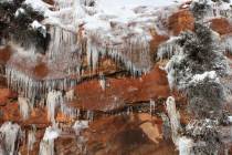
As you drive along this section, notice the colorful formations at the base of the mesa, resulting from geothermal activity. A compendium of red, pink, orange and purple, these formations are locally known as The Paint Pots.
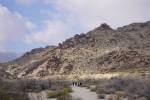
After reaching the trailhead, a small parking pullout, just walk up the wash to the left and go right and up to the ridgeline. You will find a worn path that you follow as it undulates for about three-quarters of a mile to a small saddle. The spot is marked by a large pile of 3- to 4-foot boulders on your left.
From here, just head up the steep scree slope the best way you can until you reach the base of the cliffs. Once here, go right and head carefully along the path until you see a break in the cliff face.
Usually, there are a few rock cairns here to mark the spot, but don't rely on seeing them because they often get knocked down. Watch very carefully for the cleft, because if you miss this break, you'll soon come to major drop-offs and will find it impossible to continue.
Once you find the cleft, climb up and use the any cairns you see to guide you up to the top of the mesa. This can be a tricky and dangerous climb where many people need help getting up but it is short. Once up on top of the mesa, pick up the obvious trail that first heads southwest and then west.
Follow the trail west all the way across the mesa to the large rock outcropping. As you get closer, you will probably see a large cairn and an old wooden pole marking the summit. There is an ammunition box that holds a small journal to record your journey. The comments from hikers who were here before you make an interesting read. A couple of times I have opened the box to see that the journal was missing. It later reappeared, and I'm not sure where and why it went in the meantime.
The views from this vantage point are worth the climb. To the northwest, you can see the Strip, and beyond that, the Spring Mountain Range and Mount Charleston. To the north, you can see the Muddy Mountains and to the southwest, the McCullough Range.
The one distraction of hiking Fortification Hill is the constant and annoying helicopter traffic that flies overhead, on the way to Grand Canyon and other destinations of airborne sightseeing.
The Kingman Wash Road and the side road to the trailhead are best driven in a high-clearance vehicle, preferably with four-wheel drive and good off-road tires. Because the gravel road leading to the trailhead is mainly in a wash, save this hike for another day if it is raining or threatening to do so.
Deborah Wall is the author of "Great Hikes, A Cerca Country Guide" and "Base Camp Las Vegas: Hiking the Southwestern States," published by Stephens Press. She can be reached at deborabus@aol.com.
DIRECTIONS From Las Vegas, take U.S. Highway 93 south through Boulder City and into Arizona. Continue about one mile and exit to Kingman Wash Road (Approved Road 70). Drive 5.2 miles on a well-maintained gravel road and turn right on Fortification Road (Approved Road 70 C), where four-wheel drive is recommended and high clearance required. Continue for 2.5 miles to parking pullout and signed trailhead on the left. Caution: Flash flood danger.