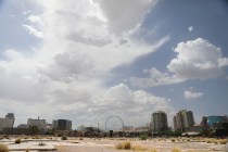
Up to a quarter-inch of rain fell over most of the valley before tapering off. Delays of more than 3 hours slowed flights before conditions improved.
Las Vegas breaking news from Nevada's most reliable source. Read about the latest updates happening in Las Vegas at reviewjournal.com.
Up to a quarter-inch of rain fell over most of the valley before tapering off. Delays of more than 3 hours slowed flights before conditions improved.

Harry Reid International Airport set a daily heat record Monday. But don’t expect the warmth to last longer than a few days.

“It will be really nice through Tuesday into Wednesday,” said meteorologist John Salmen. “The whole (storm) wave starts up north and works its way toward us during the week.”

Brownstone Canyon, near the Red Rock Canyon visitors center, logged 2.13 inches during the storm for the heaviest rainfall.

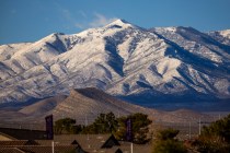
Fog and rain dominated the valley Monday, and the nearby mountains saw snow. Harry Reid airport was worst in the nation for flight delays and cancellations.

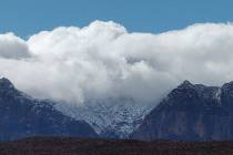
Light rain was falling mostly across the southeast valley at 5 p.m. Saturday. Snow flurries began after sunset at Lee Canyon and were expected all night.

Snow could greet Las Vegas Valley motorists Thursday morning, says the National Weather Service.
The coldest temperatures of the winter are forecast this week for the Las Vegas region.

The windy conditions across the region eased slightly on Friday. Gusts to 21 mph were reported.
Up to 9 inches of snow fell in Kyle and Lee canyons of the Spring Mountains on Wednesday, the National Weather Service said.

December ended with a record daily temperature (the mean average high and low each day) of 53.2 degrees.

Mother Nature delivered travel obstacles in Southern Nevada on Friday, with Christmas only a few days away.

Rain chances forecast to increase each day in advance of a sunny Christmas Day.
Saturday will start mostly cloudy before clearing and a high near 65 with mostly calms winds, says the Las Vegas office of the National Weather Service.

A wind advisory runs until 4 p.m. Saturday, says the National Weather Service.