Strenuous route leads to scenic overlook at Fortification Hill just outside Las Vegas


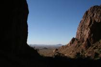
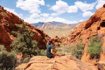
Fortification Hill, just east of the Hoover Dam on the Arizona side of Lake Mead National Recreation Area, towers about 2,000 feet above Lake Mead’s Boulder Basin. Although it looks impenetrable, there is a short but strenuous route to the top where you will be treated to some of the finest views in the park.
The “hill” is actually a mesa that was formed 5 million years ago through a series of volcanic episodes. The trail will be about 3.4 miles roundtrip and has an elevation gain of about 1,360 feet. It is not a hike for children or anyone who can’t do some short but difficult rock scrambling or handle a steep scree slope.
The trailhead is located at an elevation of 2,326 feet. From here, walk up the wash, and go right up the path that brings you up on the ridge. The trail undulates for about 1 mile, and then you will reach a well-defined saddle. Here are a large pile of 3- to 4-foot basalt boulders that seem totally out of place.
From here, you head up the steep scree slope toward the base of the cliffs. This isn’t too hard to hike on the way up, but when returning, you will definitely want a hiking pole for stability. I have seen several people fall here.
Once at the base of the cliffs, you will go right, carefully working your way for about 50 yards. Keep a sharp eye out on your left for the break in the cliff walls, which will be your travel route up. There has been a cairn in the past, but I never rely on them, as they often get knocked down. If the trail starts to descend for more than 20 feet, turn around; you have gone too far. There are extreme dropoffs in this area.
The initial climb up the cleft is the hardest. After that, just follow the easiest route up to the top of the mesa. Follow the obvious trail that heads first to the southwest and then west to the rock outcropping. You will find creosote, barrel cactus as well as Mojave yucca and silver cholla.
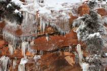
From the rocky outcropping, the views are fabulous. To the northwest, you can see the Strip and beyond to the Spring Mountains, including its tallest peak, Mount Charleston. To the north lies the Muddy Mountains. Below at the base of Fortification are the colorful Paint Pots. The reds, pinks and oranges are the result of geothermal activity.
While there, find the hiker’s register and enter what information you want to share. Be sure to glance at other hiker’s notes. Some of them are a fun read.
This hike is fully exposed to the sun the entire way. Be sure to wear a hat, sunscreen and bring plenty of water. The one big caveat with this hike is the constant helicopter traffic overhead on scenic flights to the Grand Canyon. They are low, and after the first dozen or so, it becomes very irritating. To drive to the trailhead, you will need a four-by-four high-clearance vehicle with good off-road tires for the last 2.5 miles of driving. Do not drive the road if it is raining or there is a threat of rain, as flash flooding occurs here.
Deborah Wall is the author of “Great Hikes, A Cerca Country Guide” and “Base Camp Las Vegas: Hiking the Southwestern States,” published by Stephens Press. She can be reached at deborabus@aol.com.
Directions
From Las Vegas, drive south on U.S. Highway 93 over the Hoover Dam Bypass Bridge into Arizona. Continue about 1 mile, and exit right for Kingman Wash Road. Go left and under the highway, and continue on the gravel road for about 5.2 miles. Turn right on Approved Road 70C and drive about 2.5 miles to parking and the trailhead on the left.