While barbecue connoisseurs may not consider Southern Nevada as a spot to compete with famed BBQ hot spots like Kansas City or St. Louis, a new list may make you think again.


While barbecue connoisseurs may not consider Southern Nevada as a spot to compete with famed BBQ hot spots like Kansas City or St. Louis, a new list may make you think again.

The developer said it would take $310 million to build a launching pad, a runway for spaceplanes, a control tower, a flight school and a 200-room casino resort.

Officers were diverted from another call and sped down West Charleston Boulevard to the April 8 shooting scene at the Prince Law Group in City National Bank building.

The historic downtown Las Vegas gambling hall will add two bars, a restaurant and more casino floor space later this year.

A Las Vegas woman was arrested Thursday for her alleged participation in the U.S. Capitol riot after the 2020 presidential election.

Aidan O’Connell and Gardner Minshew will compete for the starting quarterback job after the Raiders failed to address the position during the NFL draft.

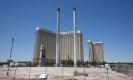
Two multibillion-dollar resorts — both with arenas that would be capable of hosting an NBA team — are in the works for Southern Nevada. Are both of them financially viable?

A 33-year-old man suspected in a series of Arts District burglaries was taken into custody Thursday, according to a news release.

For the first time since January 2005, the U.S. National Oceanic and Atmospheric Administration has issued a severe geomagnetic storm watch for Friday evening.

They are few but mighty at the moment, small crowds of longtime diehards determined to cheer their beloved A’s this year before they relocate to Sacramento for the next three seasons and, later, Las Vegas.

The community boasts views of the entire Las Vegas Valley and features properties that cost up to $6 million.

Food and drink specials, prix fixe menus, bottomless boozing and more to celebrate the mother(s) in your life.

The Sphere continues to lose money, but officials say the Las Vegas entertainment venue is improving financially and will add sound soon to its exterior display.

About 700 hospitality workers at an off-Strip casino have walked off the job and will withhold work for two days while pressing their employer to reach a deal over their five-year contract.

The on-demand beauty service that’s gained a cult following from NYC to LA has recently expanded into Las Vegas. From socialites, celebs and gala-goers to high-profile execs and busy moms, Glamsquad is the go-to beauty service for moments big and small. Glamsquad’s team of talented and trusted beauty professionals come to you anytime, anywhere. That […]


President Joe Biden and Vice President Kamala Harris welcomed the back-to-back WNBA champion Aces to the White House to celebrate their achievement.

Buzz around the music scene is, Zac Brown Band is prepping for a residency at the Sphere. The person providing the buzz is Zac Brown.

Las Vegas’ only indie-movie theater announced plans to launch a distribution arm to promote underseen films in markets everywhere.

With court losses mounting against Las Vegas taxpayers, the city on Wednesday defended continuing its legal battle with the would-be developer of the Badlands golf course.