Submerged St. Thomas now historic lesson along scenic drive


For more than 60 years, the town of St. Thomas was a legend — Nevada's Atlantis, lying deep under the surface of Lake Mead. But after drought lowered the waters in 2002 and uncovered the old settlement, it has become an interesting and educational destination, with the bonus of a scenic drive to get there and back.
The town is accessible all year, but these cooler months are a better time to visit, for the trailhead to the town itself lies at 1,227 feet and descends from there, so it can get plenty hot in summer. That said, in cooler weather, the trail is an easy one, a loop of 2½ miles.
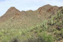
Now lying in Lake Mead National Recreation Area, it can be approached either through the recreation area's Northshore Road or the drive through Valley of Fire State Park. Both are famously scenic routes, and it's logical to enjoy one on the way there and the other coming back.
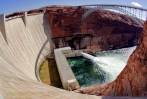
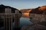
This town was occupied from 1865 until 1938, when Lake Mead — gradually forming behind the newly built Boulder Dam (now called Hoover Dam) — rose high enough to flood the town. It was no surprise; construction on the dam had been planned for years and began in earnest in 1931, so townspeople were given evacuation notices before the water started rising. Most of the residents relocated in a timely fashion. But one man, Hugh Lord, held out so long he had to depart St. Thomas by boat. The community cemetery was moved to nearby Overton, where it can be seen near the famous Lost City Museum. Many of the residents also settled in Overton and continued to visit St. Thomas whenever circumstances allowed.
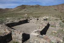
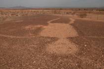
St. Thomas has emerged five times since 1938, during periods of low water, but most of those reappearances were brief. All those years underwater took their toll, so the main remnants of buildings, still visible today, are the parts made of concrete. Besides building foundations, you will also find many round or square, hollowed cement structures. These were cisterns, the common means of storing water for household use back in the day. The Park Service asks that you not climb or sit on any of the remaining walls; they're more fragile than one might imagine. You'll also notice, perhaps, artifacts such as broken bottles or iron implements. Federal law, however, requires that you leave them where you see them to enhance the experience for those who visit later. Ubiquitous shellfish shells are not exactly artifacts, but a reminder of how long the town remained underwater.
Near the confluence of the Muddy and Virgin rivers, St. Thomas was founded by Mormon pioneers, who named it for one of the group's leaders, Thomas Sassen Smith. The settlers planned to raise cotton and mine. But cotton didn't grow as well there as the pioneers had hoped. Furthermore, the settlers had believed they were in Utah until an 1870 survey showed St. Thomas was really in Nevada. Nevada officials demanded not only current Nevada taxes, but three years' arrears. Residents refused to pay, abandoned St. Thomas, and returned to Utah. The town was briefly inhabited mostly by squatters and outlaws looking for a remote hiding place, an inherently transient bunch.
But St. Thomas' location made it too valuable to remain abandoned, so it was resettled in the 1880s. The former Old Spanish Trail, by this time commonly called The Mormon Road, was Southern Utah's main link to the West Coast, and St. Thomas stood on that wagon road, at one of the few points in the Mojave Desert providing adequate water and forage for oxen and mules. When the age of the horseless carriage dawned, much of that route became part of the Arrowhead Trail, the first all-weather road between Los Angeles and Salt Lake City. St. Thomas had a hotel and several service stations and garages, and motorist guidebooks pointed out that the mechanics in those garages seemed to know what they were doing.
It also had a post office, a school, stores and a church. The village population was probably never more than 500 people, but there were more at surrounding farms and mines.
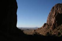
The trailhead is on a bluff overlooking the Overton Arm of Lake Mead. From here, you won't be able to see the remains, but you will be able to see a faint ribbon of green vegetation on the banks of the Muddy River. The Muddy here is making its final journey from Moapa Valley, lying to the north, down to Lake Mead. If you look a bit more to your right, or southeast, you can also see a larger tributary, the Virgin River, which flows down from Utah.
St. Thomas is a day-use area only. Don't hike the trail if it has rained recently or rain threatens, as it becomes extremely muddy. The gravel access road is suitable for most vehicles except those that are low-slung.
— Deborah Wall is the author of "Great Hikes, A Cerca Country Guide" and "Base Camp Las Vegas: Hiking the Southwestern States," published by Stephens Press. She can be reached at deborabus@aol.com.
Directions
From Las Vegas, take Interstate 15 north about 30 miles to exit 75. Drive east on U.S. Highway 169, passing through Valley of Fire State Park (a fee area), for about 25 miles. Cross over Northshore Road onto state Route 109, and drive 3.2 miles along the well-graded gravel road, staying right at the fork for St. Thomas Point and trailhead.
Alternate directions: From Las Vegas, take U.S. Highway 93/95 south to Lake Mead Drive in Henderson. Go east on state Route 146 for about 10 miles to Lake Mead National Recreation Area’s entrance station. Drive 0.3 miles, and go left onto Northshore Road. Drive about 50 miles, go left onto Route 109, and drive 3.2 miles along the well-graded gravel road, staying right at the fork for St. Thomas Point and trailhead.