
Boulder Highway to get major makeover in Southern Nevada


Boulder Highway is responsible for 9 percent of all pedestrian fatalities on Nevada roads since 2006. That sobering statistic has prompted efforts to make it safer.
A first step was pedestrian upgrades that included mid-block crossings, flashing pedestrian beacons and new lighting, updated medians and pedestrian crossing signs.
Now, fresh off the completion of those upgrades, the next round of improvements to Boulder Highway will feature multimodal options that completely change the landscape of the 15-mile stretch.
The Reimagine Boulder Highway study began in 2017 with five possible layouts for a revamped roadway. After multiple outreaches to the public and shareholders, the preferred option was picked.
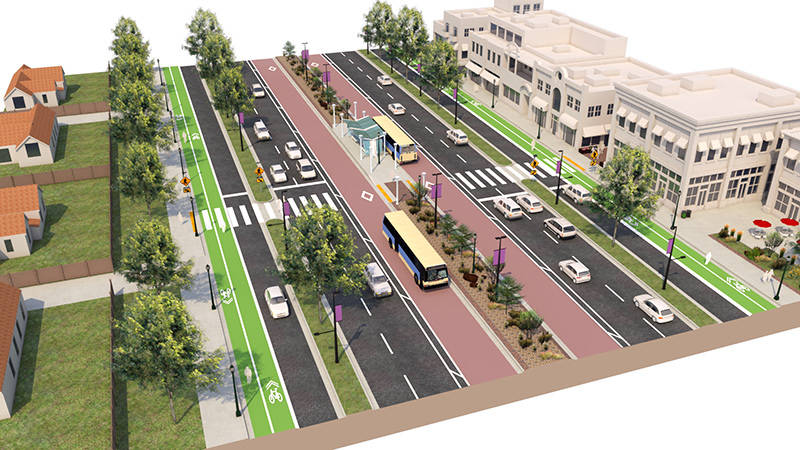
Under the plan, the highway will be divided into three sections: a “through realm” in the middle for motorists driving through the area and “pedestrian realms” on either side focused on pedestrian and bicyclist safety and allowing access to local businesses.
The through realm would be 96 feet wide and feature two general-purpose lanes in each direction and lanes for mass transit in the center of the road, as opposed to near the sidewalks, as is common on most valley roads.
“The through realm is intended to maintain traffic flow for the corridor,” said Craig Raborn, manager of planning for the Regional Transportation Commission of Southern Nevada. “There are a couple of alternative designs for that.”
A bus rapid transit route already serves that area, but the plans show that light rail could be included.
The two pedestrian realms on each side of the road would measure 41 feet wide each, with sidewalks, two bicycle lanes and a frontage road for business and residential access.
The frontage roads, which would run between the through realm and the dual bike lanes, would have a lower posted speed limit than the two general purpose lanes in each direction.
The project would stretch between Interstate 515 and Palo Verde Drive and would be carried out in six segments.
The features of the six segments could vary, depending on the characteristics of each area. For instance, the segments that lie in Henderson are not slated to include the frontage roads.
“It’s all intended to be based on what the character is for each segment,” Raborn said.
With Henderson already making the initial moves to get its portion of the project underway, Raborn said construction could start within the next two years.
According to community feedback on the proposed project, 79 percent of the 1,900 respondents approved of the concept.
Another change that could occur after the project is complete is the name of the roadway itself.
Boulder Highway was in a largely rural area when it was built in 1931 as part of the construction of Hoover Dam. Initially the highway served as the area’s only freeway, carrying state Route 5, and later U.S. Highways 93, 95 and 466 near Boulder City, through Henderson and into downtown Las Vegas.
The area has exploded since then. There are now 20,000 homes, apartments and condominiums and over 970 commercial lots within a half-mile radius of Boulder Highway. The highway also sees 10,000 RTC transit riders and 36,000 vehicles traveling on it daily.
To adapt to the changing landscape, the roadway could go from being Boulder Highway to Boulder Parkway or another name along those lines.
Not only would the project change the layout of the area, but it also would become technologically advanced with the inclusion of smart city elements, according to Mohammad Farhan, principal transportation planner for the RTC.
Cameras, alert systems, connected cars, mobile phone connectivity, smart traffic signal automation and public transit could be incorporated into the plans, Farhan said.
“The smart technology would improve the safety and mobility in the corridor,” he said.
Contact Mick Akers at makers@reviewjournal.com or 702-387-2920. Follow @mickakers on Twitter.


