
Mojave National Preserve perfect escape for those seeking serenity


The desert can be an unforgiving place four or five months out of the year.
Maybe that’s why you never see many people around Mojave National Preserve, a protected 1.6 million-acre expanse less than two hours south of downtown Las Vegas.
A little more than a half-million people visited the preserve in 2012, according to the most recent visitation figures available.
For those who view the desert as wasted space between Los Angeles and Las Vegas, the land is an overabundance of cactuses and creosote bushes.
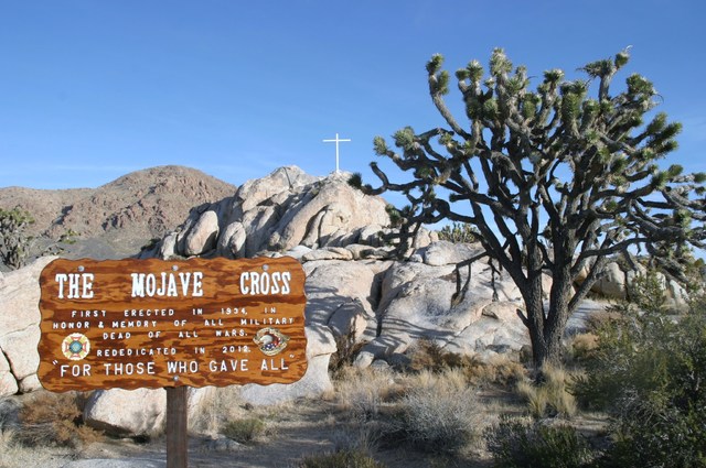
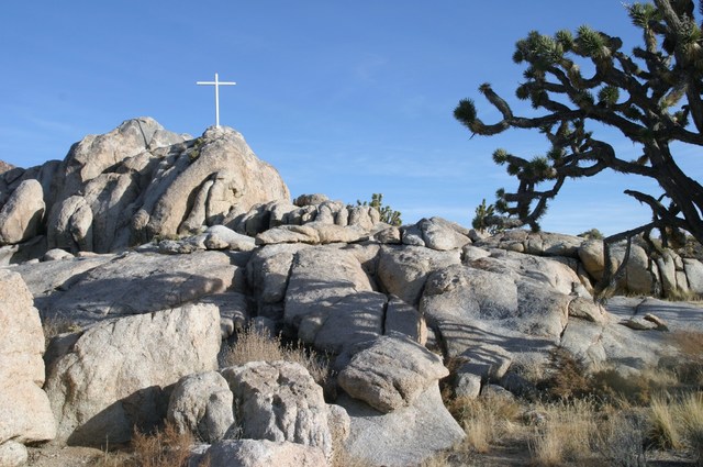
But for those with an appreciation of the rugged beauty the desert affords, Mojave National Preserve is a treasure that includes the densest forest of Joshua trees in the world, a surprising landscape of lava flows and dormant volcanic cinder cones and a historic train depot that played an important role in the expansion of the American West.
It’s home to coyote howls, drifting mountains of sand and terrain that effectively protects the people who are adventurous enough to rough it in primitive campgrounds.
And maybe the best part: It doesn’t cost anything to get in.
RELATIVELY FEW VISITORS
Perhaps because Mojave National Preserve isn’t as famous as its National Park Service counterpart to the south, Joshua Tree National Park, or to the northwest, Death Valley National Park, it provides something else most parks can’t boast — serenity.
Mojave National Preserve is the third-largest Park Service-administered unit in the lower 48 states behind Death Valley and Yellowstone national parks, but one of the least visited.
Todd Smith, Mojave’s supervisory and interpretive ranger, is trying to change that.
“I haven’t been here long, but in the time I have, I have just fallen in love with this place,” said Smith, a Las Vegan who makes the commute to the desert every workday.
PLENTY TO SEE AND DO
The biggest appeal of the preserve is that it has something for everybody. For the adventurous, there’s the Hole-in-the-Wall Rings Loop Trail, a 1½-mile walk around 4,400-foot Barber Peak along petroglyph-stamped canyon walls, Banshee Canyon and ringlets drilled into a canyon wall to provide a short and easy rock-climbing experience.
There’s Teutonia Peak Trail, Smith’s personal favorite. The 3-mile round-trip trail starts about 5 miles north of Cima, California, on Cima Road and passes through the densest Joshua tree forest in the world.
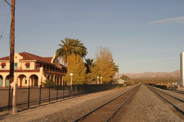
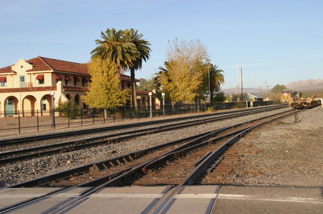
For the less hearty, there’s a center filled with historic exhibits at the Kelso Depot Visitor Center, a onetime freight train stopover on the Union Pacific line. The depot was converted to a National Park Service visitor center in 2005 — and a pretty nice one.
Today, the depot is a pit stop for freight trains along one of the routes between Southern California and Las Vegas and Salt Lake City.
The train station opened in 1905 as a station for “helper” engines to assist Union Pacific freight trains to climb the 2,078-foot ascent between Kelso and what is now Cima. Kelso was chosen for the site because of its proximity to a spring in the Providence Mountains to assist steam engines.
In the 1920s, the depot grew and became a center for railroad workers running trains in support of local mines. A dining room and dormitories were built for crewmen. When mines closed and steam engines gave way to diesels, the depot’s function waned. The population that once was 2,000 dwindled through the 1960s and in 1985, it finally closed.
When Union Pacific announced plans to demolish the building, local residents raised money to preserve it. The building’s title eventually went to the Bureau of Land Management and when the California Desert Protection Act of 1994 was approved, it passed into the hands of the National Park Service.
The rail line is still an important conduit between the docks of San Pedro and Salt Lake City.
Every half-hour or so, a freight train chugs through the depot, adding or dropping helper engines for the steep grades that lie ahead on the train route. Train buffs frequently take photos as the trains roll through.
Another popular attraction near the center of the park is the Kelso Dunes, a series of shifting mounds of sand about 11 miles southwest of the depot.
Hiking the dunes can be a literal one-step-backward-for-every-two-steps-forward experience. It’s about 3 miles round-trip.
Rangers recommend sturdy shoes and to bring plenty of water on any hike, particularly those early in the fall and late in the spring when the temperatures can easily climb above 100 degrees.
THE DESERT COMES ALIVE
Treks across the desert often are rewarded with memorable photo opportunities and encounters with nature.
Because the preserve ranges in elevation from 930 feet near Zzyzx to 7,929 feet at Clark Mountain, vegetation varies. There’s white fir, juniper and pinyon pine in the high country with Joshua trees, creosote and cholla cactus in the lowlands.
Bighorn sheep, mountain lions, mule deer, bobcats and jackrabbits make their home in the Mojave area as do coyotes and bats.
The skies across the desert also are filled with golden eagles, red-tailed hawks, cactus wrens and ravens while roadrunners dart among the brush. There are believed to be 321 bird and 51 mammal species living in the preserve.
Another popular resident of Mojave is the desert tortoise, a familiar desert denizen.
Reptiles, mostly snakes and chuckwallas, inhabit the rocky areas. While Mojave has its share of venomous snakes, including rattlers, the nonpoisonous common kingsnake and gopher snakes dot the landscape.
The desert’s insect world includes a variety of spiders. Tarantulas are most commonly seen in the fall months when males are in search of mates. While tarantulas generally are not dangerous to humans, the area’s black widow and brown recluse spiders can produce a painful bite.
There also are moths, wasps, scorpions and ants throughout the preserve.
AN UNUSUAL PHENOMENON
There are a few surprises in some corners of the preserve.
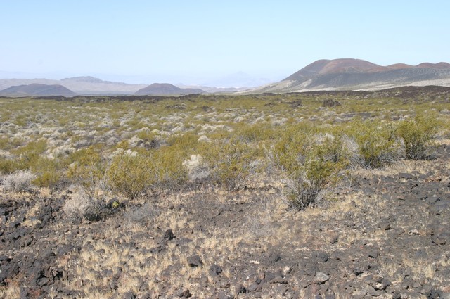
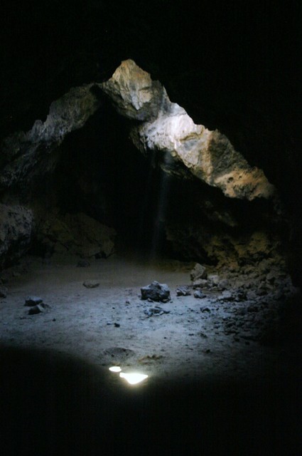
West of the Kelso Depot on the road toward Baker, California, is dusty, unmarked Aiken Mine Road, a route that winds amid cinder cones and lava fields. About 7 miles in is a bluff that runs along the top of an ancient lava tube, a cave formed when lava from long-dead volcanoes pushed through a naturally formed tunnel.
Today, there are eroded openings and vents in the rock that explorers can access. A metal stairway leads to the tube floor and, except for a few rocky low bridges, a hiker can stand within the tube and witness the shafts of light that illuminate the tunnel.
The unusual phenomenon is worth the rough road and the easy climb inside, and the tube offers cool relief from the desert heat.
Smith said the lava tube isn’t widely advertised because Aiken Mine Road has a few low-clearance areas that could damage a car, and that’s not a place you want to have to call a tow truck — if you even have cell service.
WHERE TO CAMP
Another rewarding experience worth the minimal discomfort is a night or two of roughing it in a tent or under the stars in the preserve’s campgrounds at Mid Hills and Hole-in-the-Wall.
Some of the spaces are suitable for trailers and small recreational vehicles, but there’s nothing quite like experiencing a desert sunset or sunrise or falling asleep under a canopy of stars far from the lights of Los Angeles and the neon of Las Vegas.
The 35-site Hole-in-the-Wall campground is at 4,400 feet, while the 26 sites at Mid Hills are at 5,600 feet. A fire in 2005 destroyed vegetation around half of the Mid Hills site, but the elevation alone makes for ideal sleeping temperatures in the fall and spring, and possibly even chilly in the winter months.
The high temperatures in the low desert near Zzyzyx, which sits at 930 feet above sea level, can be uncomfortable, even at night.
Campsites are $12 a night and are available on a first-come, first-served basis. There are no reservations.
The National Park Service also encourages roadside camping, particularly in areas previously used by other motorists.
STEERING CLEAR OF TROUBLE
Travelers should always check a reliable weather forecast before venturing into the desert because, like most desert environments, when the rain comes, it comes with reckless abandon. It’s not uncommon for dry desert washes to fill and overflow, taking out roadways with flash floods.
There are other hazards.
Funding shortages have been unkind to California parks and many of the paved roads are full of potholes. It isn’t wise to build up too much speed on park roads because of the possibility of an encounter with a nasty pothole.
Smith said a federal highway grant paid for several road repairs last year so many of the highways that were in poor shape in the past have been fixed.
In addition, one of the park’s neighboring features has been closed since 2011. Mitchell Caverns, on the southeastern boundary of the preserve and home to California’s only known limestone caverns, is an astonishing display of stalagmites, stalagtites and various cave formations. Accessible off Interstate 40, Mitchell Caverns cave tours had been operated by California’s Providence Mountains Recreation Area. A public support group has been working for years to reopen the cave.
Contact Richard N. Velotta at rvelotta@reviewjournal.com or 702-477-3893. Follow @RickVelotta on Twitter.
If you go
There are several access points to the 1.6 million-acre Mojave National Preserve. From downtown Las Vegas on Interstate 15, the preserve can be accessed from exits on Nipton Road (52 miles), Cima Road (66 miles) and Kelbaker Road (109 miles).
The Kelso Depot Visitor Center is 93 miles from Las Vegas on I-15 via Cima Road and the Mid Hills Campground is 90 miles via Nipton Road.
Admission to the preserve is free.
Camping fees at Mid Hills and Hole-in-the-Wall campgrounds are $12 a night on a first-come, first-served basis with no reservations.
Popular hiking spots
Among the most popular hikes in the Mojave National Preserve, many of them starting near Hole-in-the-Wall in the center of the park, are:
• Mid Hills to Hole-in-the-Wall Trail. It's 8 miles one way through a series of dry washes past barrel and cholla cactus fields. With an elevation difference of 1,200 feet, the trail traverses the Hackberry Fire burn area.
• Hole-in-the-Wall Nature Trail. The 5-mile loop winds through several varieties of desert plant.
• Lake Tuendae Nature Trail. The quarter-mile hike around Lake Tuendae is 5 miles south of I-15 on Zzyzx Road.


