


Air quality is expected to be in the moderate category or perhaps a bit worse Monday as smoke from wildfires continues to drift into the Las Vegas Valley.
Air quality is expected to be in the moderate category or perhaps a bit worse Monday as smoke from wildfires continues to drift into the Las Vegas Valley.

Las Vegas was seeing hazy conditions on Sunday thanks to the Post Fire north of Los Angeles which started Saturday afternoon.

Atomic Golf customers had called its bays “stifling.” The off-Strip facility said it has fixed its system and is offering guests other ways to stay cool.

After two days of official 108 highs, Thursday and Friday are projected to reach around 106. Winds could gust to 22 mph Thursday, giving a blow dryer feel to the day.

The forecast high for central Las Vegas is 108 on Tuesday and 109 on Wednesday, both just below record highs for the dates.

Snowfall could impact travel on I-15 between Las Vegas and Southern California from late Sunday through Tuesday morning.
The scenic drive and visitors center at Red Rock Canyon won’t open until 9 a.m. Friday, officials said.

Some patchy morning fog around sunrise Thursday remains a small possibility in the Las Vegas Valley, according to the latest National Weather Service forecast.
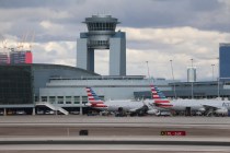
All travelers flying into and out of McCarran International Airport are urged to check with their airline to determine their flight is affected.

Meteorologist Clay Morgan said there were no reports of flooding in the valley, but that there was lots of “ponding” in intersections and on the sides of roads across town.

The National Weather Service said Saturday’s high temperature is projected to be 48 degrees with a low of 33 degrees. That forecasted high temperature is just off the record low high of 47 degrees set in 2006.
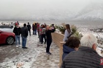
Snow started to fall Wednesday morning as a winter storm moved into the Spring Mountains and Sheep Range near Las Vegas.

The Las Vegas Valley could see snow this week as a major winter storm heads toward the Great Basin just in time for Thanksgiving, according to the National Weather Service.
Snow was falling in the Spring Mountains Wednesday morning, a part of the storm that brought rain to the Las Vegas Valley and Southern Nevada.

Widespread rainfall late Tuesday and Wednesday — the first for the Las Vegas area in two months — led to water rescues, traffic tie-ups and power outages across the valley.

Institutional trading is the heavyweight league of finance, where banks, hedge funds and asset managers make their moves. While individual traders might not have direct access to an institutional cryptocurrency trading platform, there are ways to get in on a piece of the action. Investing in institutional-grade funds or following their trading strategies offers a […]
Air quality is expected to be in the moderate category or perhaps a bit worse Monday as smoke from wildfires continues to drift into the Las Vegas Valley.

Atomic Golf customers had called its bays “stifling.” The off-Strip facility said it has fixed its system and is offering guests other ways to stay cool.

After two days of official 108 highs, Thursday and Friday are projected to reach around 106. Winds could gust to 22 mph Thursday, giving a blow dryer feel to the day.

The forecast high for central Las Vegas is 108 on Tuesday and 109 on Wednesday, both just below record highs for the dates.


