
Large swath of Spring Mountains closed to public
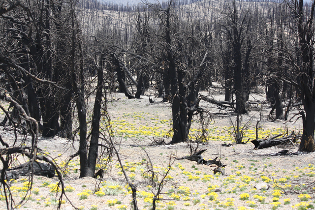


Federal officials plan to close thousands of acres in the Spring Mountains north of Red Rock Canyon for the next five years to give the area time to recover from last year’s Carpenter 1 Fire.
The Bureau of Land Management, which operates Red Rock Canyon National Conservation Area, announced its portion of the temporary closure Wednesday with a notice in the Federal Register.
Starting Oct. 24, the bureau plans to bar public access to almost 5,700 acres at the northern end of the conservation area, including Harris Springs Road. The road, which leads through one of the areas hardest hit by the fire, will be closed at state Route 157, the highway to Kyle Canyon.
BLM spokeswoman Kirsten Cannon said private property owners along the Harris Springs Road will still be allowed access.
The closure does not impact the most heavily visited portions of Red Rock Canyon, including the scenic drive and its hiking trails.
Cannon said the area may need to remain closed for as long as five years because of the extent of damage from the fire and subsequent flash floods and the amount of time and resources needed to stabilize and rehabilitate the area.
“The closure is also needed to help address public safety and adjoining private property due to the potential for future downstream flooding from loss of vegetation and topsoil until the area is stabilized and rehabilitated,” the BLM said.
The rehabilitation work is being done by the BLM, U.S. Forest Service, Nevada Department of Wildlife and the Clark County Department of Public Works.
Anyone caught entering the closed area is subject to arrest and prosecution and could face up to a year in prison and a fine of up to $1,000.
The BLM said its closure matches the Forest Service’s closure for the area.
Forest Service land burned by the lightning-sparked Carpenter 1 Fire last year, including several popular hiking trails on Mount Charleston, is off-limits under a pair of closure orders that do not include specific expiration dates.
The Forest Service closed the Harris Springs area to its boundary with BLM-managed land in November. Hiking paths leading through the burned area, including the Cathedral Rock Trail, Griffith Peak Trail and South Loop Trail, were not officially closed until March, though hikers were not allowed there after the fire.
Officials from the Spring Mountains National Recreation Area and the Humboldt-Toiyabe National Forest could not be reached for comment Wednesday.
Contact Henry Brean at hbrean@reviewjournal.com or 702-383-0350. Find him on Twitter: @RefriedBrean.

CLOSURE AREA
Click to see a large map of the closure, or scroll down to find a Google map.


