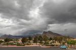
Strong storms, hail strike parts of Southern Nevada


Thunderstorms producing heavy rainfall and some hail caused minor problems on Las Vegas Valley roadways Sunday but prompted the Nevada Department of Transportation to close a stretch of U.S. Highway 93 in Lincoln County.
The bouts of rain, along with the accompanying cooler temperatures, are expected to be gone by Tuesday.
Clark County and much of Southern Nevada had been under a National Weather Service flash flood watch for the past three days.
One of the hardest hit areas of Southern Nevada was Lincoln County, where about two hours of hard rainfall caused the Nevada Department of Transportation to shut down U.S. 93 between Alamo and the junction of state Route 318. The highway links Las Vegas to eastern Nevada.
The department could not be reached for an estimate of how long the highway would be closed.
The weather service received no reports of severe flash flooding in the Las Vegas Valley on Sunday, but heavy rainfall in Henderson on Sunday afternoon led to 3 to 4 inches of water on some streets about 2:30 p.m.
Small hail "about the size of a dime" pounded the Summerlin area of Las Vegas around 10 p.m., but the storm moved through the area and to the northeast in about 15 minutes, according to several observers. Small hail was later reported in Centennial Hills and North Las Vegas.
Minor flooding on Mount Charleston in Kyle Canyon was also reported. Two hours earlier, rain washed rocks and boulders onto Deer Creek Road. No roadway closures or injuries occurred, according to a spokesman for the Nevada Division of Forestry station in Kyle Canyon.
Sunday's rainfall totals illustrated the nature of the rain - hard and fast. Henderson received the most at 0.35 inches. North Las Vegas received 0.20 inches, and the Las Vegas Wash near Sahara received 0.13. All other measuring stations received zero or trace amounts of rain.
There is a 20 percent chance of rain today, but clear, sunny skies are expected Tuesday through the rest of the week.
The return of dry air means temperatures will likely climb back into the triple-digits by Thursday, according to the weather service.
Contact reporter Ben Frederickson at bfrederickson@reviewjournal.com or 702-224-5512.