
5 years after Carpenter 1 fire, Mount Charleston begins to heal


Five years later, the pale skeletons of dead trees still mark the path of one of the largest wildfires ever to strike Spring Mountains National Recreation Area.
But there are also signs of life in the shadow of the blaze known as Carpenter 1.
Green patches of bushes and shrubs now color much of the almost 19,000 acres of federal land that remain closed to the public as the landscape slowly heals.
Soil scientist Jim Hurja stopped his white U.S. Forest Service pickup along Harris Mountain Road on Friday to hop out and survey the new growth.
“We’re seeing recovery,” he said.
Then he started calling out the names of some of the native plants sprouting along the rugged dirt road, some of them in full bloom: Gambel oak, Palmer’s penstemon, ricegrass, rabbitbrush, snakeweed, silk tassel, snowberry, creeping Oregon grape.
“I even see sagebrush coming back, which is good to see,” Hurja said.
He also spotted several four-legged reasons for optimism: wild burros and young bucks with fur-covered antlers grazing through the once-blackened forest.
Flames then flooding
The Carpenter 1 Fire roared to life on July 1, 2013, and burned for more than a month, scorching almost 28,000 acres in the mountains west of Las Vegas.
By the time it was contained, it had churned through several different ecosystems, from high-elevation bristlecone pines to Joshua trees near the desert floor.
Some of the worst damage occurred in and around Harris Springs Canyon, from the eastern flank of Griffith Peak to state Route 157. Hurja said almost 95 percent of the watershed burned in the lightning-sparked blaze, which also claimed several structures on two parcels of private land in the canyon.
The flames were soon followed by unprecedented flooding, as storm water raced down mountainsides suddenly stripped bare of the plants that once held the rocks and dirt in place.
“All the good top soil ended up in the yards (of houses) in North Las Vegas,” said Donn Christiansen, who manages Spring Mountains National Recreation Area for the Forest Service.
The service and the Bureau of Land Management responded by closing almost 30 square miles of public land, including all of Harris Springs Canyon and the dirt roads leading into it.
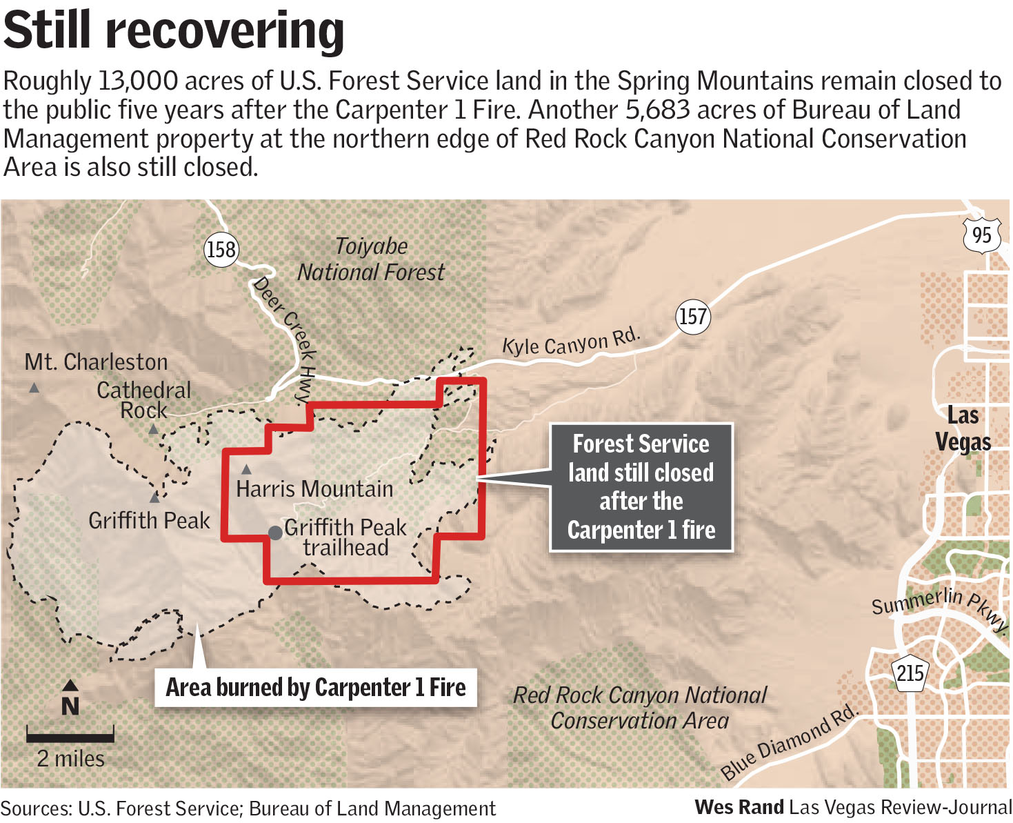
CLICK TO ENLARGE
The current, five-year closure order is set to expire at the end of January, but Christiansen expects it to be extended at least into 2020.
Though the landscape has begun to recover, he said, it’s still in a fragile and dangerous state, with increased risks of flash flooding and hundreds of dead trees just waiting to topple over.
A plan to plant pinyons
Hurja said some of the dead trees could be cut down or left where they fall to stabilize hillsides and curb flooding.
Eventually, he said, the Forest Service plans to replant a portion of the burned area with pinyon trees now being grown at the agency’s nursery in Idaho from seeds gathered in the Spring Mountains.
As far as he knows, this will mark the first time anyone has tried planting pinyon trees after a fire in the range.
But most of the recovery will have to occur naturally, and it won’t happen quickly.
“Maybe in 10 or 20 years we’ll start to see trees resprouting,” Hurja said. “It’s going to take some time.”
“Mother Nature has a long-term restoration plan,” Christiansen added. “We just try to help the process along when we can.”
But not all new growth is welcome.
Hurja pointed out several patches of cheat grass and tumbleweed, two stubborn invasive plants that tend to spread after a wildfire, then serve as fuel for future fires.
That’s another reason for the closure, Christiansen said. Invasive weeds and grasses can hitch a ride into new territory on people’s cars, clothes, horses or dogs. Keeping people out gives the native plants a better chance of outpacing the invaders.
The top of the road
After nearly 6 miles of rocky switchbacks, Harris Mountain Road ends at a dirt parking lot for the Griffith Peak Trail, the only major hiking route still closed on Mount Charleston.
The hillside above the trailhead is studded with the burned husks of mountain mahogany, white fir and pinyon, many of them with green shrubs, even wildflowers, clustered beneath them.
The burned remnants of trail signs still rest in the brush, but just up the trail is a new wooden plaque that marks the boundary of the Mount Charleston Wilderness Area.
Christiansen said work to clear the Griffith Peak Trail of fallen trees and flood damage is ongoing. He hopes to see it finished in a year or two, just in time for the Forest Service to finally lift the closure order and reopen the roads into Harris Springs Canyon.
Contact Henry Brean at hbrean@reviewjournal.com or 702-383-0350. Follow @RefriedBrean on Twitter.
How you can help
Donn Christiansen, who manages Spring Mountains National Recreation Area for the U.S. Forest Service, said anyone who wants to help with the ongoing recovery efforts from the 2013 Carpenter 1 Fire can join one of the volunteer projects organized throughout the year by groups such as Friends of Nevada Wilderness, the Southern Nevada Conservancy and the Great Basin Institute.
Mountain visitors can also help by not making things worse.
Christiansen said the burned area will recover faster if people observe closure signs, stick to designated roads and trails and wash their cars, clothes and shoes before venturing up the mountain to prevent the spread of invasive weeds and grasses.
It would also help if everyone followed the rules and guidelines designed to prevent the next wildfire, he said.


