
Tracking Hilary: Mount Charleston seeing flooding, Death Valley breaks record


Developments in Southern Nevada as Hilary, formerly a hurricane and now a tropical storm, hits the western United States:
Lee Canyon remains closed through Friday
Lee Canyon announced in a news release that it will remain closed as the U.S. Forest Service’s closure of the Spring Mountain National Recreation Area remains in effect.
Tropical Storm Hilary dropped 9.8 inches on the resort over the weekend, according to the resort.
Resort staff will assess the storm’s impact on the resort once the closure is lifted, and will then decide if it will need to remain closed.
“Lee Canyon’s priority is to ensure public safety,” Dan Hooper, Lee Canyon’s general manager, said in a news release.
— Taylor Lane, 6:46 p.m., Monday
Lake Mead, Red Rock Canyon Scenic Drive to reopen Tuesday
Lake Mead National Recreation Area will reopen Tuesday after closing on Saturday in anticipation of Tropical Storm Hilary, the National Park Service announced Monday.
The park service said in a news release that most facilities and services are operating, except for Las Vegas Boat Harbor which was damaged by a monsoon storm on Friday and the Callville Bay Marina, which is without power.
“Thankfully, there were no injuries and facilities received minimal damage in the wake of this storm,” said Acting Superintendent Mike Gauthier in the news release. “We are pleased to announce we are open for business again.”
The park service encouraged people who find damage in the park to report it to park personnel.
Red Rock Canyon’s Scenic Loop and Visitor Center are also excepted to reopen Tuesday. The Scenic Loop is planned to reopen at 6 a.m. and the Visitor Center is slated to reopen at 8 a.m., Red Rock Canyon announced in a post.
Red Rock Canyon warned people traveling on the Scenic Loop on bicycles and motorcycles to use extra caution as there may still be debris on the road.
— Taylor Lane, 5:43 p.m., Monday
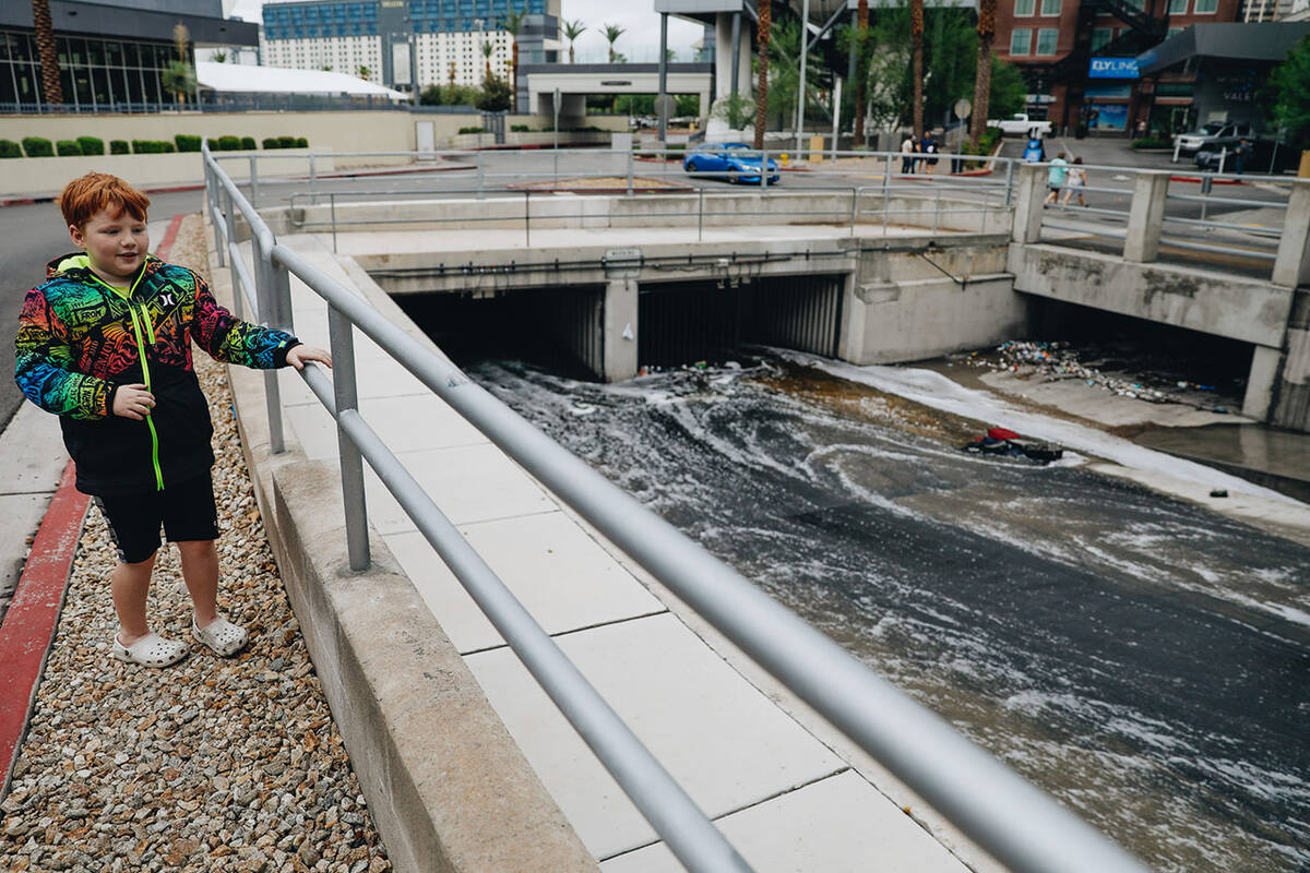
Rainfall totals for weekend show heaviest rainfall near Mount Charleston, Lee Canyon
Rainfall totals from the weekend show Lee Canyon and Mount Charleston received the highest rainfall totals in Southern Nevada and got nearly 8 inches of rain between Friday and Saturday night, according to the National Weather Service.
New video shows the damage to SR-157/Kyle Canyon Rd near the Mt. Charleston community. SR-157 remains closed in both directions near SR-158. NDOT is working with the NV National Guard to create one temporary lane to get vehicles by. pic.twitter.com/BqrutnPCR0
— Nevada DOT Vegas (@nevadadotvegas) August 21, 2023
Henderson saw some of the lowest rainfall totals near Raiders Headquarters, where the Clark County Regional Flood Control District recorded between 0.31 and 0.39 inches of rain between 2 p.m. Saturday and 2 p.m. Monday.
The Las Vegas Valley averaged about 0.55 inches of rain from Saturday night to Monday at 11 a.m., the weather service said.
Other high rain gauge totals were recorded in Red Rock Canyon and Summerlin West, according to the flood control district. The valley received the most rain west of Durango Drive, the weather service said.
— Taylor Lane, 3:52 p.m., Monday
Joshua Tree to reopen Tuesday
Joshua Tree National Park, closed because of Tropical Storm Hilary, will reopen Tuesday to day use only, the National Park Service said.
The national park saw heavy rains and flooding from Hilary, and crews were clearing roads in the park of debris and sand.
Road crews found large amounts of sand and debris on roadways and have begun clearing the roads, according to a statement from the park.
When Joshua Tree reopens Tuesday, all visitor centers and paved roads will be open, while all dirt roads and campgrounds will still remained closed until further notice while crews continue to clean up and assess storm impacts.
— Brett Clarkson, 3:39 p.m., Monday
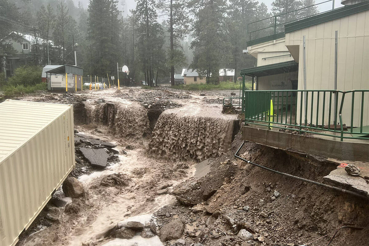
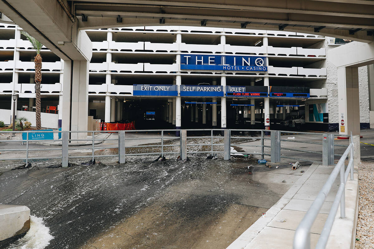
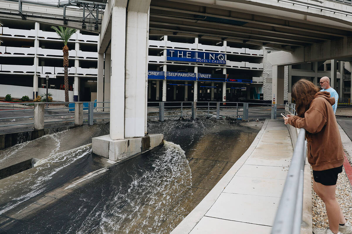
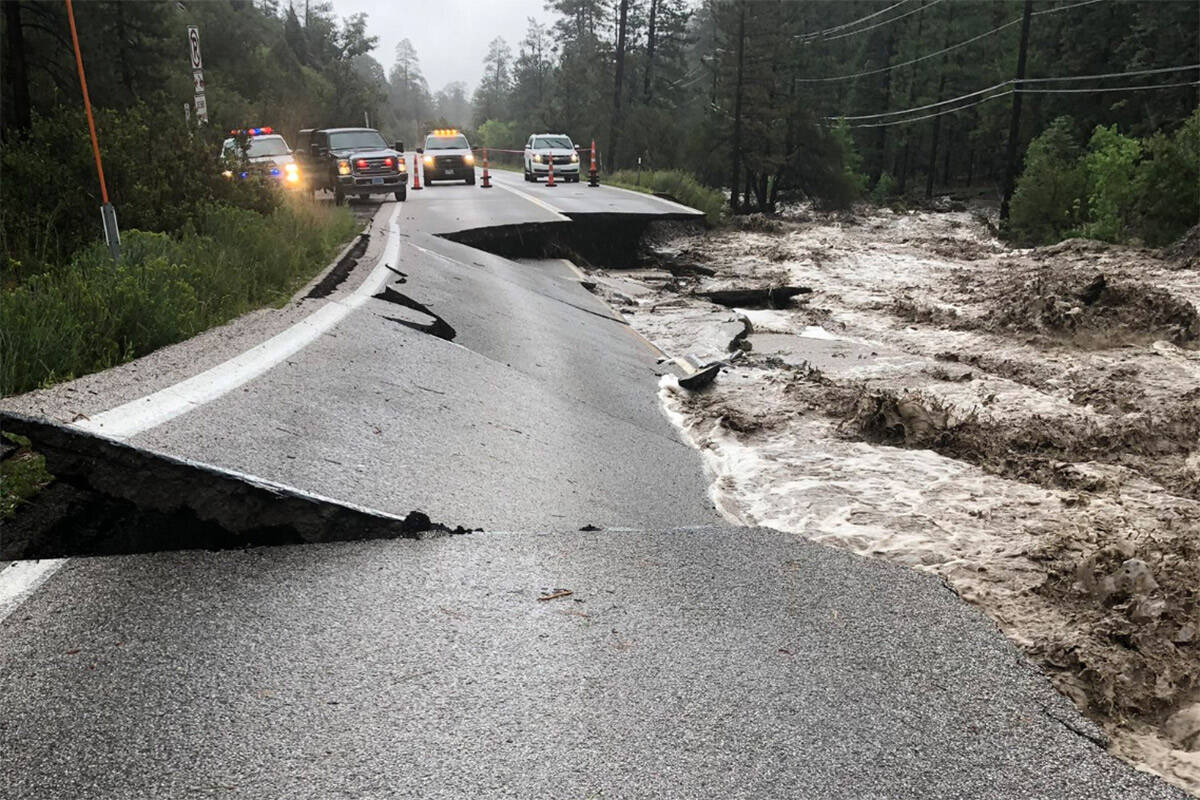
Kyle Canyon Road near Mount Charleston sees ‘extensive damage’
Major damage to Kyle Canyon Road due to heavy rain and flash flooding has made accessing people in Mount Charleston’s three subdivisions, Old Town, Echo and Rainbow, difficult.
The total population of the subdivisions was difficult to estimate because of seasonal residents, but authorities estimated about 150 to 200 people were sheltering in place Monday, according to Mt. Charleston Fire District Chief Jorge Gonzalez.
Authorities were working to create a temporary lane to Mount Charleston, Nevada Department of Transportation spokesperson Justin Hopkins said.
A long cleanup ahead on @GoMtCharleston after rains brought by #Hilary did widespread damage. A #FlashFlood Warning is still in effect. Upper Kyle Canyon & Mt. Charleston had 7 inches of rain, 8 inches in Kyle Canyon.
⁰Amazing images from our Mt. Charleston Fire Protection Dist. pic.twitter.com/Z30LTpvvbX— Clark County Nevada (@ClarkCountyNV) August 21, 2023
Trails and campsites are planned to stay closed through Friday as officials assess damage in the area, U.S. Forest Service spokesperson Taylor Tims said.
— Sabrina Schnur, 3:21 p.m., Monday
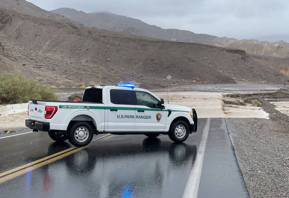
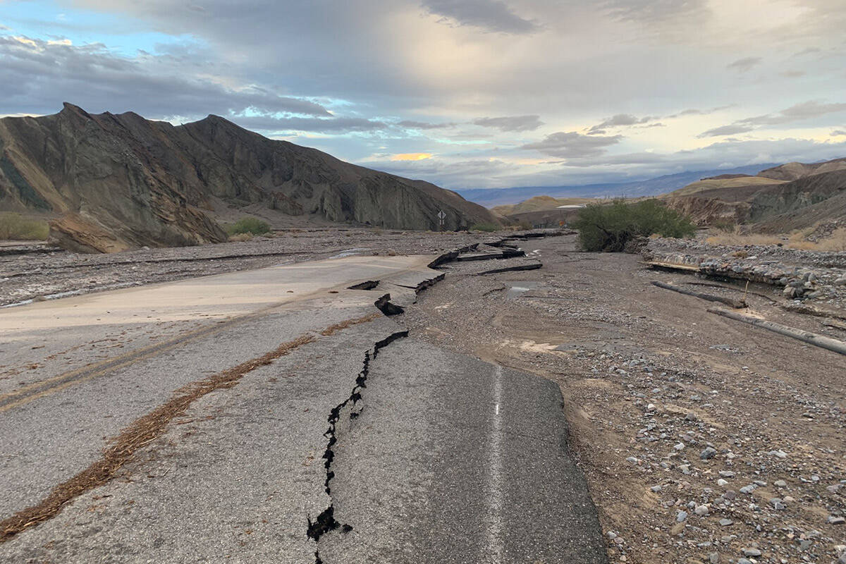
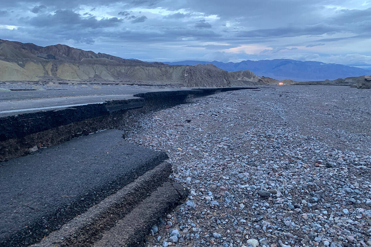
Death Valley breaks rainfall record, 400 people stuck in park
Death Valley National Park broke its record for its wettest day in recorded history after the park received 2.20 inches of rain on Sunday, according to the National Weather Service. Weather records for the park go back to June 1911.
This broke the previously set record of 1.70 inches of rain on Aug. 5, 2022, when over a thousand people were stranded in the park due to flash flooding and road destruction.
The National Park Service said in a release Monday afternoon that the park received the rain in two large bursts on Sunday, with about an inch of rain in the morning, and an inch of rain at night.
The park is still closed as staff assess damage to park facilities, Caltrans said in a post.
About 400 residents, employees and travelers are sheltering in place in Furnace Creek, Stovepipe Wells and Panamint Springs until roads are safe the pass, the park service said. The park service said it did not know when the first parts of the park to reopen will reopen, but said it was working with Caltrans to clear an exit route to the park on California State Route 190, also known as Death Valley Scenic Byway.
The park service said it was working with California Highway Patrol to search for other people stranded in remote areas of the park.
The Nevada Department of Transportation closed Nevada State Route 267, also known as Scotty’s Castle Road, in both directions. The road connects U.S. Highway 95 to the California border and leads into the park.
The park service’s said its land line telephones are still down in the park, and said that they are also working to fix a broken sewer line which is releasing raw sewage into the desert below Stovepipe Wells.
— Taylor Lane, 3:15 p.m., Monday
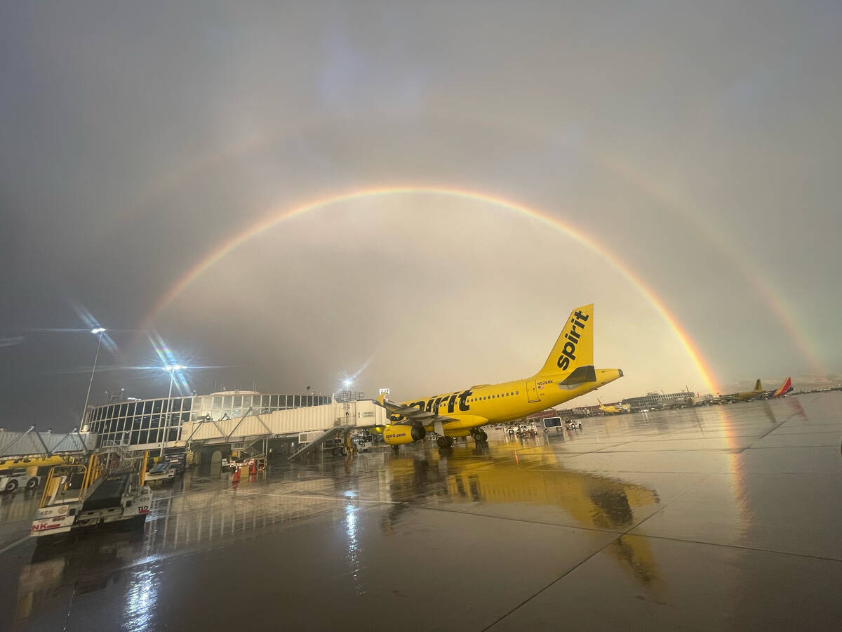
Cancellations, delays continue at Harry Reid Airport
Tropical storm Hilary continues to affect travel at Harry Reid International Airport.
There were 53 cancellations and 94 delays, according to Flight Aware. The airport suggests checking with your airline to see if your flight has been delayed or cancelled and to give yourself extra time getting to the airport.
— Lukas Eggen, 8:20 a.m., Monday
Kyle Canyon under boil water order
The Kyle Canyon Water District has issued a boil water order for all Kyle Canyon residents. All Kyle Canyon customers are also asked to shut off irrigation systems until further notice.
Severe overnight flooding on Mt. Charleston – and specifically within Kyle Canyon – caused a severe leak in the Kyle Canyon Water System, resulting in major reservoir tanks losing water pressure, the water district said. A rolling boil of three minutes is sufficient.
Water district crews will remain on the mountain until repairs are complete, but no timeline was given. The boil water order will remain in place until the issue has been fixed.
The Las Vegas Valley Water District operates the Kyle Canyon Water District.
In addition, the old town area and Rainbow subdivision on Mt. Charleston saw substantial flooding, according to Clark County. Residents are sheltering in place. State Route 157 and SR 158 at 157 are shut down and the power is currently off. The Nevada National Guard is on the way to assist. A shelter location for residents is located at 2755 Kyle Canyon Road.
— Lukas Eggen, 6:30 a.m., Monday
Flood watch remains in effect through this afternoon
A flood watch remains in effect for parts of Southern Nevada until 5 p.m. Monday, the National Weather Service said. Affected areas include northeast Clark County, western Clark, southern Nye County, the Sheep Range, Spring Mountains, Red Rock Canyon, Las Vegas Valley, Lake Mead National Recreational Area and southern Clark County.
There is a 50 percent chance of showers and thunderstorms, mainly before 1 p.m., the NWS said. Mostly cloudy conditions will gradually become sunny with a high near 86.
— Lukas Eggen, 5:15 a.m., Monday
High wind warning to 5 a.m.
Southeast winds of 25 to 35 mph with gusts up to 60 mph are expected. Wind gusts to 70 mph are possible near Mount Charleston, says the National Weather Service.
The area includes northeast Clark County, western Clark and southern Nye County, the Sheep Range, Spring Mountains-Red Rock Canyon and Las Vegas Valley.
Damaging winds may blow down trees. Power outages are possible. Travel will be difficult, especially for high profile vehicles.
Strong winds will be relatively brief as the remains of decaying Hilary lift through the western Mojave Desert. Several hours of strong winds are likely with gusts of 50 to 60 mph in the valley and to 70 mph near Mount Charleston.
Flash flooding caused by excessive rainfall continues to be possible through 5 p.m. Monday as a result of increased moisture from Hilary.
A portion of southern Nevada, including the following areas: Lake Mead National Recreation Area, Las Vegas Valley, northeast Clark County, Sheep Range, Southern Clark County, Spring Mountains-Red Rock Canyon and western Clark and southern Nye County.
Showers are likely Monday with possibly a thunderstorm before 9 a.m., then a chance of showers and thunderstorms. Some storms could produce heavy rain. Cloudy, then gradually becoming mostly sunny, with a high near 85. South southeast wind 13 to 17 mph, with gusts as high as 25 mph. Chance of precipitation is 60 percent.
— Marvin Clemons, 10:30 p.m., Sunday
Flood advisory until midnight
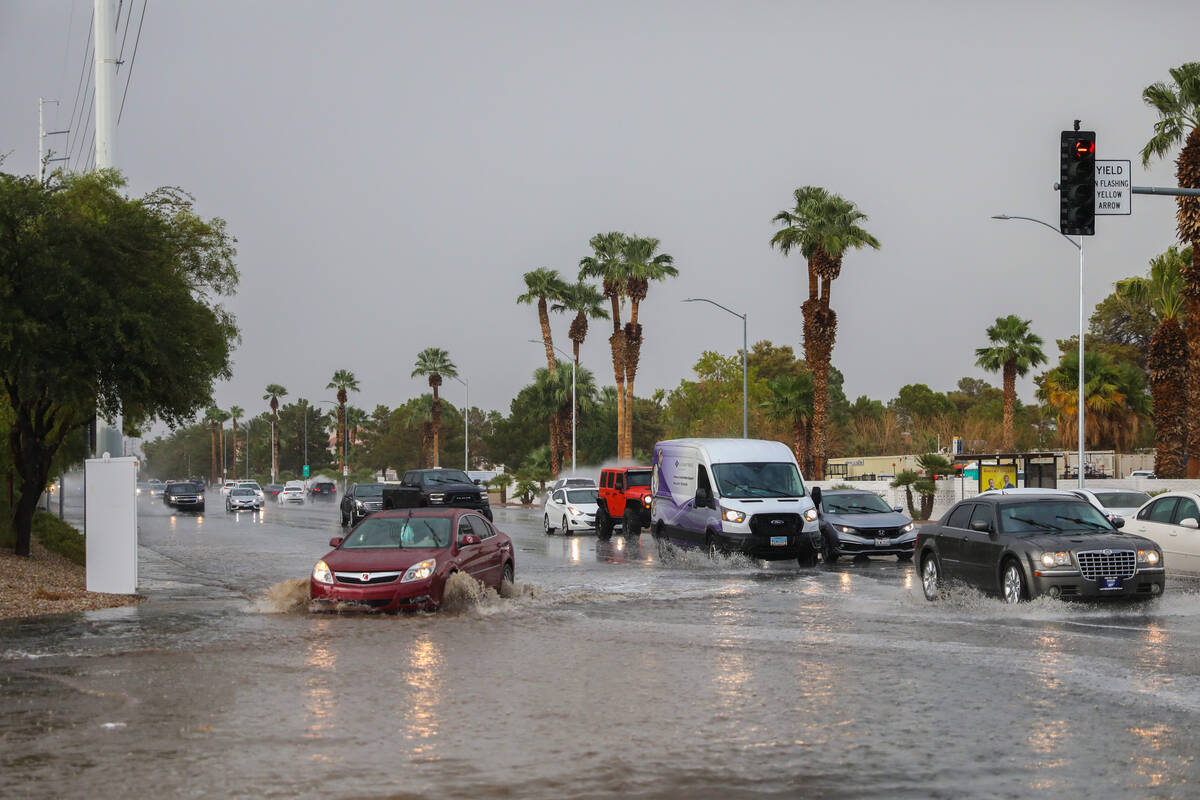
A flood advisory in effect until midnight tonight. Minor flooding is possible in Las Vegas, Henderson, North Las Vegas, downtown Las Vegas, The Strip, Paradise, East Las Vegas, Spring Valley, Green Valley, Nellis AFB, Sam Boyd Stadium, Enterprise, Aliante, Southern Highlands, Lone Mountain, Summerlin, Las Vegas Motor Speedway, Mountains Edge, Anthem and Centennial Hills.
Flooding caused by excessive rainfall is expected. Minor flooding in low-lying and poor drainage areas. Minor flooding is ongoing or expected to begin shortly in the advisory area.
— Marvin Clemons, 9:33 p.m., Sunday
Flash flood warning
A flash flood warning runs until 10 p.m. for southwestern Clark County.
At 7:59 p.m., Doppler radar indicated thunderstorms producing heavy rain across the warned area. Flash flooding is ongoing or expected to begin shortly. Some locations that will experience flash flooding include Bullhead City, Boulder City, Laughlin, Searchlight, Jean, Primm, Nipton Road Mile Marker 3, Cal-Nev-Ari, Cottonwood Cove Campground, Cottonwood Cove, Goodsprings, Big Bend Rec Area, Sandy Valley and Willow Beach, said the National Weather Service.
— Marvin Clemons, 9:27 p.m., Sunday
Warning about ponding
The National Weather Service is warning about water ponding across portions of the Las Vegas Valley. Though the water is not flowing, it may become too deep for cars to drive through it. Do not risk it; turn around, don’t drown.
— David Wilson, 9:20 p.m., Sunday
Las Vegas on quiet side of storm
The heaviest rainfall from Hilary is hitting California and it appears it may stay that way through the evening, says the National Weather Service.
“But we don’t want to let our guard down,” meteorologist Marc Austin said. “If we get a heavier band that rolls through or becomes stationary then we still have a flash flood risk.”
Austin said some heavier bands were developing on the southern edge of Clark County at 6:30 p.m. and could arrive in the valley in 1 to 2 hours.
“They could produce a half-inch to an inch an hour,” he said. “But certainly, the heaviest precipitation is in San Bernardino and Inyo counties, much closer to the circulation (of the storm).”
As far as during the night, it all depends on where rain bands develop.
“We’ve had some drier air on this side (of the storm) that has limited the precipitation,” he said.
— Marvin Clemons, 6:40 p.m., Sunday
Pahrump shelter opened
Shelters were opened in two Southern Nevada communities Sunday to assist individuals displaced by damage and flooding caused by Hilary.
However, only the Red Cross shelter in Pahrump at Bob Ruud Community Center, at 150 N. Highway 160, was used, said a Clark County spokeswoman. In Searchlight, a shelter at Searchlight Community Center, 200 Michael Wendell Way, was opened but not used.
“We were asked to open the one in Searchlight today because the park service evacuated Cottonwood Cove,” Stacey Weiling said. “It’s ready to go if needed.”
The Red Cross placed supplies, cots, blankets, water and snacks, in Moapa and other Clark County locations in anticipation of flooding.
Shelters are also available in Moapa and Logandale, Weiling said.
— Marvin Clemons, 6:05 p.m., Sunday
Flash flood warning near Needles
A flash flood warning has been issued for Needles, Mountain Pass, Mitchell Cavern, and the York Fire burn scar until 7 p.m., says the National Weather Service.
— Marvin Clemons, 4:27 p.m., Sunday
I-15 closed in Barstow
The Nevada Department of Transportation said Interstate 15 is closed in both directions at its convergence point with Interstate 40 in Barstow, California. The duration of the closure is unknown at this time.
NDOT said to expect long travel delays.
The California Highway Patrol website showed the road was closed shortly before noon because of a fire on the west side of Barstow near L Street.
The closure will cause travel disruptions between Southern California and Las Vegas.
— Taylor Lane, 3:30 p.m., Sunday
Death Valley closes
Death Valley National Park closed Sunday due to active flooding, the National Park Service said in a statement.
The park received 1 inch of rain mid-day Sunday, and expected “unprecedented levels” of rainfall over night, the park service said.
Flash floods have already begun in the park. Furnace Creek Visitor Center received 1.04 inches of rain by 1:30 p.m. — nearly half of the amount of rainfall Furnace Creek receives on average in an entire year, according to the park service.
California Highway 190, also known as the Death Valley Scenic Byway, is also closed. The park service advised travelers to not drive through flooded roads, as emergency responders may be unable to reach people who need help.
— Taylor Lane, 3:00 p.m., Sunday
Evacuations at Lake Mead NRA
A evacuation order was issued Sunday afternoon for Temple Bar and Willow Beach areas of Lake Mead National Recreation Area.
Due to flooding risks from Tropical Storm Hilary, the National Park Service was requesting that everyone in the area evacuate to higher elevations.
— Marvin Clemons, 2:35 p.m., Sunday
Nye County School District cancels school
Nye County School District cancelled classes and all extra-curricular activities Monday due to tropical storm Hilary and in response and encouraged Nye County residents to shelter in place in a news release.
The district advised people to “Be safe! Stay home!” and instructed all district employees to stay home unless they were told otherwise by a supervisor.
— Taylor Lane, 2:25 p.m., Sunday
Lombardo declares state of emergency
Gov. Joe Lombardo declared a state of emergency due to the imminent threat from Hilary, as current forecast models predict severe weather across the state of Nevada.
The emergency declaration follows Lombardo’s decision to activate 100 Nevada National Guardsmen to Southern Nevada earlier this weekend. Additionally, the Federal Emergency Management Agency (FEMA) deployed staff, including an Incident Management Team, to Nevada on Saturday to further support the state’s response efforts.
“I implore all Nevadans to prepare for flooding, remain vigilant, and to follow all guidance from state and local emergency officials.”
As a result of the anticipated rainfall from Hilary, flash flooding, rockslides, mudslides and washouts are expected to cause significant damage to state infrastructure and public and private property.
The declaration of emergency will enable the state and impacted counties and tribes to receive federal assistance as they work to protect residents and mitigate infrastructure damage from Hilary.
— Marvin Clemons, 1:18 p.m., Sunday
We just pulled out from the Universal lot and we’ve already seen several streets and intersections flooded. Please be safe! Coverage all day live on @NBCLA #Hilary pic.twitter.com/q7Yg8uDt3q
— Alex Rozier (@AlexNBCLA) August 20, 2023
Flights cancelled at airport
Hundreds of flights out of and into Las Vegas’ Harry Reid International Airport were cancelled on Sunday.
According to FlightAware.com, 325 flights into and out of the airport were cancelled Sunday.
The bulk of those canceled flights are Southwest Airlines, with 266, or 51 percent. In addition, cancellations include 24 for Frontier, 11 for Spirit, eight for Allegiant, eight for JetBlue, six for United, and two for Breeze.
— Brett Clarkson, 1:08 p.m. Sunday
CCSD classes to continue Monday
Clark County School District said classes are expected to continue as normal on Monday.
The district is monitoring weather conditions, and if schools are impacted by the storm, the district will update parents through ccsd.net, ParentLink and the district’s social media accounts.
— Taylor Lane, 12:30 p.m., Sunday
Delays at airport
Flights to Harry Reid International Airport are being delayed at their departure airports because of low visibility.
According to FlightAware.com, there have been 182 delays of flights into or out of Harry Reid so far on Sunday.
Delays are averaging 101 minutes, according to a Federal Aviation Administration website.
All Las Vegas-bound flights in the 48 lower states are affected.
Lower visibility limits the numer of flights that can land per hour.
The airport will also close to private flights for several hours this afternoon, officials said.
— Marvin Clemons, 12:15 p.m., Sunday
Valley rain expected to get stronger
Las Vegas Valley residents can expect increased showers and possible thunderstorms arriving late Sunday afternoon or in evening hours, says the National Weather Service.
If thunderstorms develop, they could come with wind gusts of 40 to 50 mph, said weather service meteorologist Morgan Stessman.
Stormwater flows through @ClubatSunrise Golf Course at 10:10 am Sunday morning. This is the confluence of Flamingo Wash and Las Vegas Wash. The wash is working as designed.#WaterAlwaysWins #Flood #Flooding #HurricaneHilary #Hilary #LasVegas #ClarkCounty pic.twitter.com/Y6u50fRzEU
— Regional Flood (@RegionalFlood) August 20, 2023
As of 11 a.m. Sunday, the weather service was projecting a half-inch on the east side for the day with upward to three-fourths of an inch on the west side. That would change locally if thunderstorms develop, Stessman said.
“Most of the expected heavy rainfall has shifted west toward San Bernardino County, Death Valley (National Park) and into Inyo County,” Stessman said.
Any thundershowers in Las Vegas could lead to flash flooding.
“There is a lot of moisture out there,” she said. “If we do get some clearing, that could allow some heating to drive thundershowers.”
The Monday outlook is for lesser rainfall, perhaps a tenth of an inch overall, Stessman said, adding that Sunday appears to be the primary day for precipitation.
The latest weather service projections show the heaviest rain from Tropical Storm Hilary falling from Death Valley and northward west of Barstow.
— Marvin Clemons, 11:43 a.m., Sunday
Avoid washes, Mount Charleston, Red Rock
Don’t go to Red Rock, Mount Charleston, or the Spring Mountains if you don’t have to, forecasters are warning. And do not step foot into any of the concrete washes around the valley.
“Outdoor recreation will be very dangerous in the Spring Mountains including Mt. Charleston and Red Rock, and is strongly ill-advised,” said a flood watch, which remained in effect Sunday for Las Vegas and portions of Southern Nevada through Monday afternoon.
“Absolutely do not enter concrete washes in the Las Vegas Valley,” said the watch. “These washes will become very dangerous and potentially deadly.”
— Brett Clarkson, 11:35 a.m., Sunday
Wind gusts to 75 mph on Mount Charleston
A high wind warning, issued by the National Weather Service and is in effect from 2 until 5 p.m. Sunday. Mount Charleston could see winds up to 75 mph.
The strongest winds Sunday are generally expected to be 25 to 35 mph, with gusts up to 60 mph, in the Las Vegas Valley and Southern Nevada.
Wind gusts of 75 mph are possible near Mount Charleston. To put that in context, Category 1 hurricanes are characterized by sustained gusts of at least 74 mph. While the gusts in this case aren’t expected to be the sustained winds seen in hurricanes, 75 mph winds are powerful and potentially dangerous.
— Brett Clarkson, 11:30 a.m., Sunday
Nye County sees historic flood impact
Nye County issued a declaration of existence of local emergency Sunday morning in a news release.
The county said it has high confidence that there will be high or historic flood impacts in the county and in Inyo and San Bernardino counties in California.
Death Valley and Morongo Basin in eastern San Bernardino County are expected to see most of the major flooding, the county said.
Police informing neighborhoods in the San Bernardino mountains of being cut off by flash flooding tonight and tomorrow with Tropical Cyclone Hilary. Catastrophic flooding expected @accuweather pic.twitter.com/4F10RFnJgo
— Reed Timmer, PhD (@ReedTimmerAccu) August 20, 2023
Nye County warned that Pahrump and Amargosa Valley are forecast for extreme flooding Sunday afternoon, and residents should stay at home and avoid traveling.
The county’s Emergency Management Operations Center has been activitated, and public works and the Sheriff’s Office are working together in case of a flood event, the county said.
A flood watch is in effect for southern Nye County until Monday evening, and in effect in northern Nye County until Tuesday morning. Limited sandbags are available at the Pahrump Valley Fire and Rescue on Highway 160, the county said.
There are also high wind warnings for southern and northwestern Nye County until Monday evening, the county said.
The Red Cross has also created a 100-person temporary structure in Pahrump that the National Guard will assist, the county said.
— Taylor Lane, 10:50 a.m., Sunday
County calls state of emergency
Clark County declared a state of emergency to ensure that resources from state and federal agencies can be available as quickly as possible for county residents, the county said in a statement. The county added that it did not expect its operations or employees returning to work Monday to be impacted by the storm.
The county has a page on its website with emergency related information in English and Spanish. You can go here.
— Taylor Lane, 10:10 a.m., Sunday
Roads seeing rain impacts, low visibility
Roads were seeing the impact of storms Sunday morning with U.S. Highway 95 and State Route 164 seeing delays in Searchlight because of down power lines. Ute Road near Interstate 15 was also closed due to flooding, but was not impacting traffic on the interstate Sunday morning, according to the Nevada Department of Transportation.
Visibility was low on U.S. Highway 93 between Kingman and the Hoover Dam, the weather service said, and on the Pahrump Valley Highway near Mountain Springs, NDOT cameras showed Sunday morning.
Though heavy rain was expected in Las Vegas Sunday, the weather service said the areas with the highest risk of dangerous flooding in Nevada were western Clark County near the Spring Mountains, Nye County and southern Esmeralda County. Southeastern California cities Victorville, Barstow and San Bernardino were also at a high risk of heavy rainfall leading to flash flooding.
Temperatures in Las Vegas were expected to stay below 90 Sunday with a high of 83 degrees. Temperatures were in the high 60s Sunday morning at Harry Reid International, the weather service said.
The weather service encouraged people during Hilary to not drive through flooded roads.
— Taylor Lane, 8:30 a.m., Sunday
Downgraded to Cat 1
Hurricane Hilary is here, and moisture, wind and flash flooding from the weather event are expected throughout the valley all day Sunday into Monday evening.
Hilary was downgraded to a Category 1 storm early Sunday morning, but the impacts of heavy rain remain a concern for Southern Nevada with a flash flooding watch still in effect into Monday along with a high wind warning Sunday afternoon and overnight, the National Weather Service said. Winds 40 to 60 mph or greater are possible.
Early morning rain drenches Spring Mountains
Less than half an inch of rain was reported in the early hours of the day on Sunday across most areas in the Las Vegas Valley, with the exception of Mount Charleston and Lee Canyon areas where many rain gauges from the Clark County Regional Flood Control District recorded over half an inch.
One rain gauge in the Spring Mountains had already recorded over an inch of rain for the day on Sunday at 8 a.m.
— Taylor Lane, 8:00 a.m. , Sunday
Officials: Stay home, stay safe
It has the potential to be a storm unlike any seen or felt before in the Las Vegas Valley.
After light, but steady rain across the entire region much of Saturday, conditions are expected to intensify Sunday.
Some are calling it a storm you see once every 100 years. Best to ride it out at home.
“The most important safety message we can tell the public at this time as we brace for impacts from Hurricane Hilary is to stay home if you can during this event, and don’t drive, walk or ride through flooded areas or flood control channels,” Clark County Fire Chief John Steinbeck said.
— Marvin Clemons, 12:10 a.m., Sunday
Heavy flight cancellations
More than 130 flights into Harry Reid International Airport on Sunday have been canceled, with Southwest Airlines scratching more than 680 0f its total domestic flights, as heavy rain storms from Hurricane Hilary are forecast that day for the Las Vegas Valley.
The airline flight website FlightAware reported Saturday afternoon that Reid had called off 134, or 20 percent, of its incoming flights for Sunday, while another 131 flights, or 19 percent, leaving Harry Reid were also canceled.
Southwest had canceled 681 flights, or 16 percent of the airline’s total scheduled takeoffs for the day.
San Diego International Airport has put off 103, or 34 percent of its incoming flights, while Phoenix Sky Harbor International has canceled 57, or 10 percent, and Hollywood Burbank Airport has canceled 43, or 37 percent, according to FlightAware.
—Jeff Burbank, 7:20 p.m., Saturday
Radar back in operation
The National Weather Service has at least temporarily repaired its tracking radar for the Las Vegas area that went out Friday night.
“It appears as though it has been fixed for now,” meteorologist Morgan Stessman said. “It was a problem with a high-voltage cable and one has been ordered.”
Until the part is received and put into place at the radar site some 15 miles south of Boulder City near Nelson Peak, the radar could go out again, Stessman said.
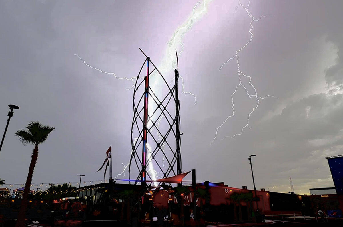
A meteorologist said late Friday night the radar appeared to have been hit by lightning. The weather service’s radar also went down in May.
“It’s back up for now and we are keeping our fingers crossed,” she said, noting a crew was at the site for 6 to 7 hours Saturday and was able to get the radar working shortly after 4 p.m.
—Marvin Clemons, 5:30 p.m., Saturday


