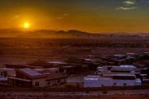
Arizonans prepare as rain moves into state

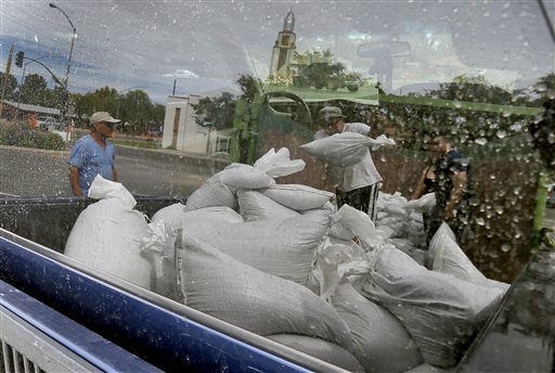


TUCSON, Ariz. — People lined up in bumper-to-bumper traffic and scooped sand into trash and canvas tote bags Wednesday as rain from a weakened Pacific storm began to fall on Arizona.
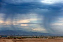
It’s the second blast of hurricane-related weather to hit the desert region in the past two weeks — the result of an especially active Pacific storm season. Odile was once a Category 3 Hurricane, but was downgraded to a tropical depression by the time rain started falling in Arizona.
Storm activity is expected to pick up during the day, and the forecast called for Tucson to get slammed with up to 5 inches. Phoenix was expected to get soaked but with lesser amounts.
Fearful of widespread flooding, people across Arizona rushed to fill up sandbags to fortify their homes. Traffic backed up at two parks in Tucson where they were being given out. The mayor of the border city of Nogales used his pickup truck to deliver sandbags to residents.
More than 40 people with bags and shovels huddled around a pile of sand as a steady rain fell at Reid Park. The pile dissipated in just minutes. It was the third pile since the makeshift sandbag station opened at 8 a.m. in the parking lot, said Cat Beddard, a Tucson Parks & Recreation employee.
Griselda Valenzuela showed up with her 1 ½-year-old son and hoped to get 10 bags. “I don’t want the house flooding and my son walking around,” Valenzuela said.
Odile tore through the Mexican resort state of Baja California Sur late Sunday and Monday, where residents were still struggling Wednesday with a lack of power and drinking water. There were scattered reports of looting, and the Los Cabos airport was closed to commercial travel.
About 70 miles south of Tucson, officials in Nogales have spent the past week preparing for storms. Nogales is downhill of Nogales, Sonora, Mexico, meaning rain water from the Mexican side doesn’t take long to seep into the city’s washes.
“This happens to us ever year. We don’t need a hurricane for us to get flooded,” Mayor Arturo Garino said. “This time we’re being very, very proactive.”
At the Arizona Department of Transportation’s Traffic Operations Center, agency spokesman Doug Nintzel and other workers looked over a bank of monitors that showed traffic statewide and the track of the storm as it moved from Mexico into the U.S.
“It is unusual for us,” he said. “We would be expecting to start getting into the drier fall season here in the area, so you never know with Mother Nature, and we’ve just said all hands on deck. You need to prepare for this type of thing, and we’re doing the best we can, trying to keep our system as operational as possible.”
Weather and climate experts said it’s rare to have back-to-back weather events like this in Arizona.
The Eastern Pacific hurricane season is 50 percent more active than usual, while the Atlantic is 50 percent less active. The result has been fierce storms striking Mexico in recent weeks, while the Atlantic had its first major hurricane — Edouard — form just this week.
Last week, the remnants of Hurricane Norbert caused deadly flash flooding in Arizona. The single-day rainfall totals in Phoenix eclipsed the average total precipitation for the entire summer. Freeways became submerged after pumping stations could not keep up with the downpour, and sections of Interstates 10 and 17 were closed most of the day.
Despite the heavy rains, it still might not be enough to pull Arizona out of its drought.
Rain alone will not help refill reservoirs on the Colorado River. The current drought is drawing down Colorado River storage — in Lake Mead and Lake Powell in particular — to dangerous levels, said Jonathan Overpeck of the Institute of the Environment at the University of Arizona. The snowmelt from snowpack is what fills reservoirs that supply drinking water. So the upcoming winter, not hurricane season, is a crucial weather period.