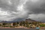
Cooler weather on tap, rain possible by midweek


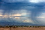
As temperatures drop over the next few days, precipitation in the Las Vegas Valley and nearby mountains isn’t expected to return until the middle of next week, the National Weather Service said.
After Saturday’s high of 61 degrees, temperatures are expected to drop to 40 overnight. There is a 20 percent chance for light snow in the mountains Saturday night, but the mountains and valley will then be dry for a few days, said meteorologist John Salmen.
“We won’t have anything else after that,” Salmen said. “Looks like Wednesday afternoon the chances start increasing again for the mountains.”
Wednesday is expected to have a 30 percent chance of rain in the valley, and 40 percent chance of snow in the mountains during the day. Snow chances will then increase to 60 percent in the mountains from Wednesday night into Thursday morning, Salmen said.
The valley should expect a 40 percent chance of rain on Thursday, he said.
Temperatures will decrease after Saturday to an expected high of 54 on Sunday, followed by 52 on Monday. The high Tuesday and Wednesday should be about 55, followed by an expected high of 53 Thursday.
Overnight lows should be in the low 40s to high 30s through Thursday, the weather service said.
Contact Katelyn Newberg at knewberg@reviewjournal.com or 702-383-0240. Follow @k_newberg on Twitter.