
Pacific storm may bring rain, highs in 80s to Las Vegas

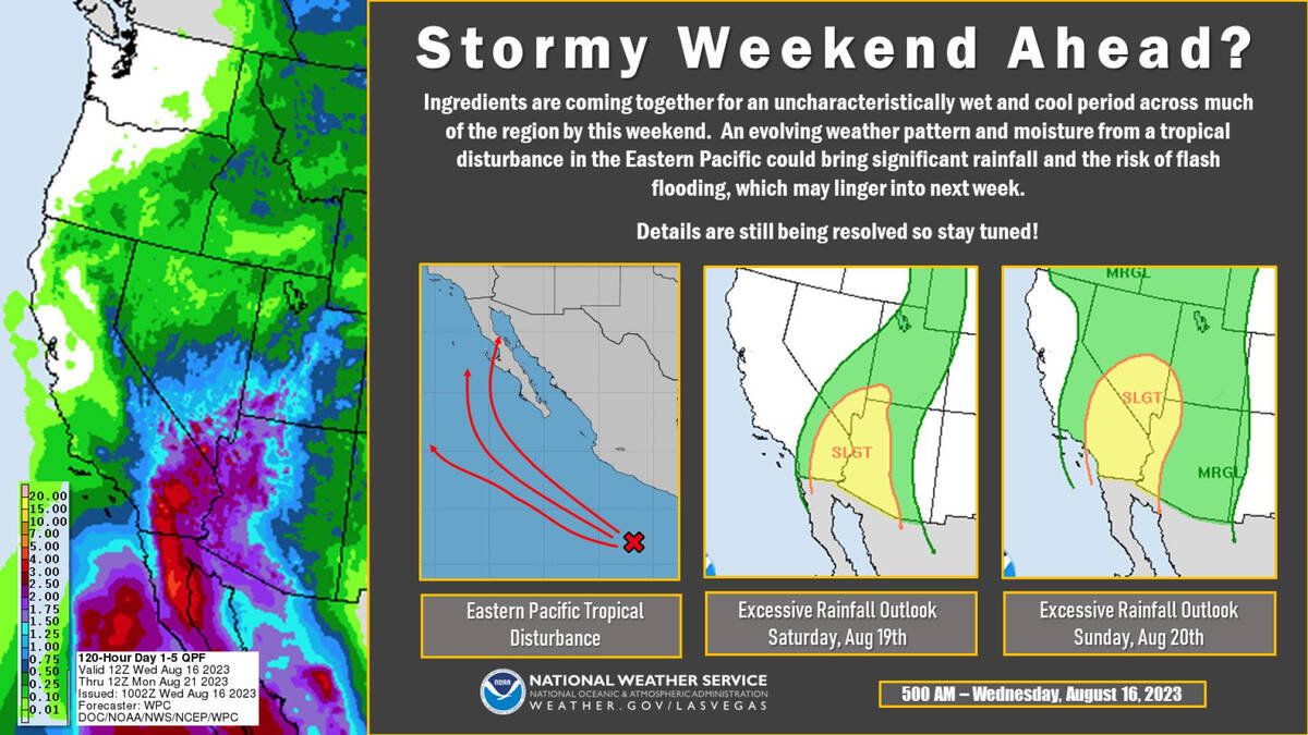


A growing tropical storm in the eastern Pacific Ocean is projected to move into the Southwest, making for a potentially wet and cooler weekend in Las Vegas.
Hilary, which strengthened from a tropical storm to a hurricane on Thursday, could drop significant rainfall in the region from Southern California to Arizona starting late Saturday, according to the National Weather Service.
“Our best chances for rain are Sunday into Monday,” meteorologist Jenn Varian said. “We have widespread rain forecast for the whole weekend.”
Varian said of particular concern are Death Valley National Park and the 93,000 acres that burned late last month in the York Fire, which started in the Mojave National Preserve in California and crossed into Nevada.
“It would take very little rain there,” for flash flooding, she said.
With the projected rainfall, temperatures will cool considerably. A Saturday high of 92 and a Sunday high near 80 are forecast. Monday may warm to around a high of 86.
The current Las Vegas forecast lists a 70 percent chance of rain Saturday, increasing into Sunday and Monday.
“We show it increasing each day,” Varian said.
Showers and thunderstorms are in the forecast through Wednesday.
Arizona, California, Mexico flooding
As Hilary gains intensity off the southwest coast of Mexico and moves northwestward, there is growing concern about its potential impact on the Southwest — mainly in the form of flash flooding. The storm is forecast to become a hurricane by the end of the week.
Flash flooding is a concern in the mountainous regions of western Mexico, California and western Arizona, which are particularly prone to mudslides, AccuWeather said.
Any heavy rain brings the potential for flash flooding, road washouts and debris flows, with with fast-rising waters.
Impact scenarios
A more eastward track could lead to widespread heavy rain and flooding across the Southwest and western Mexico, while a westward track could limit heavy rainfall to localized areas. Likewise, damaging winds would be more pronounced with an eastern track, while a western track probably would spare the region from such wind effects, according to AccuWeather.
While Hilary is expected to remain offshore, localized damaging wind gusts could still affect parts of Baja California from Saturday to Monday. And the western coast of Mexico through Southern California should expect high waves and surf because of the storm.
Such California storms rare
Although not currently forecast, a landfall in Southern California is not fully out of the question. If it were to occur, it would be very rare — only occurring a few times in recorded history.
Southern California has seen notable tropical cyclone events throughout history, including the 1858 unnamed hurricane that affected San Diego. And the El Niño of 1938-1939 brought four tropical cyclones with substantial rainfall to the region. Hurricane Kathleen in 1976 and Hurricane Linda and Hurricane Nora in 1997 also left their mark with flooding rainfall and gusty winds.
Contact Marvin Clemons at mclemons@reviewjournal.com. Follow @Marv_in_Vegas on X.


