
Temperatures are expected to drop to the low 60s for Thanksgiving Day, the National Weather Service said.
Temperatures are expected to drop to the low 60s for Thanksgiving Day, the National Weather Service said.

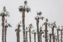
Parts of Mount Charleston saw up to 11 inches of snow Monday night, but the National Weather Service said the frosty weather isn’t expected to continue this week.

Thunderstorms caused flash flooding around the Las Vegas Valley on Monday, shutting down a few intersections. Red Rock Canyon National Conservation Area also saw flash flooding.

Las Vegas this week is expected to break 100 degrees for the first time this year, prompting an excessive heat watch by midweek.

Gusty winds caused a power outage Sunday on Mount Charleston, according to NV Energy, but power will not be restored until 10 a.m. Monday as a precaution due to extreme fire weather conditions.
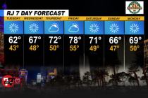
Monday’s cold front will likely clear out by Tuesday morning, leaving cool but dry temperatures across Las Vegas, according to the National Weather Service.

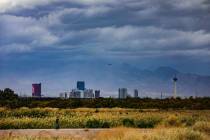
Blustering winds ripping through the Las Vegas Valley late Monday marked the start of cooler weather — and possible rain — for the week.
The highest chance of snow in the central valley won’t come until Tuesday morning, according to the National Weather Service.

There was no measurable rain at McCarran International Airport or in Henderson or North Las Vegas as of 6:45 p.m. Monday.

The western Las Vegas Valley may see some snow pellets Monday. Mount Charleston will likely see a few inches during the storm.